IMAGES TAKEN NEAR TO
Windmill Rise, CREWKERNE, TA18 7BZ
Introduction
This page details the photographs taken nearby to Windmill Rise, TA18 7BZ by members of the Geograph project.
The Geograph project started in 2005 with the aim of publishing, organising and preserving representative images for every square kilometre of Great Britain, Ireland and the Isle of Man.

There are currently over 7.5m images from over14,400 individuals and you can help contribute to the project by visiting https://www.geograph.org.uk
Image Map
Images are licensed for reuse under creativecommons.org/licenses/by-sa/2.0
Notes
- Clicking on the map will re-center to the selected point.
- The higher the marker number, the further away the image location is from the centre of the postcode.
Image Listing (25 Images Found)
Images are licensed for reuse under creativecommons.org/licenses/by-sa/2.0
Image
Details
Distance
1
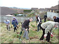
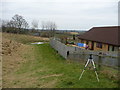
Crewkerne : Bincombe Beeches Nature Reserve
People gathered to plant trees on the Bincombe Beeches Nature Reserve.
Image: © Lewis Clarke
Taken: 28 Feb 2009
0.02 miles
2
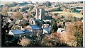
Frosty Crewkerne Morning
Photo taken from under Bincombe Beeches showing the Church and the surrounding buildings
Image: © Jeanette Rendell
Taken: 2 Dec 2007
0.04 miles
3
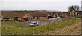
Crewkerne : Beechwood Drive & Bincombe Beeches Nature Reserve
A new residential area for people in Crewkerne which overlooks the nature reserve.
Image: © Lewis Clarke
Taken: 28 Feb 2009
0.05 miles
4
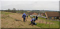
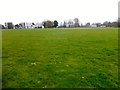
Crewkerne : Bincombe Beeches Nature Reserve
The Town Council owns and manages this natural and peaceful countryside haven
which can be found on the north side of the town. The reserve derives its name from the magnificent line of beech trees, some between 150 and 200 years old, which majestically crown the town side of the hill.
Image: © Lewis Clarke
Taken: 28 Feb 2009
0.06 miles
5
Crewkerne : Bincombe Beeches Nature Reserve
It is home to over 30 species of birds, including woodpeckers, goldcrests and jackdaws, and many varieties of wild animals, such as badgers, foxes and grey squirrels.
Image: © Lewis Clarke
Taken: 28 Feb 2009
0.07 miles
6
Ashlands Road, Crewkerne
From the junction with Beechwood Drive, and dropping down towards its junction with the A356.
Image: © Derek Harper
Taken: 27 Apr 2019
0.11 miles
7
Fairy Hill
Parked near the cemetery in Crewkerne then used footpaths to access Bincombe Beeches Nature Reserve and the flat grassy summit with wide views. Bagged with Alex and Smudge.
Name: Fairy Hill
Hill number: 18276
Height: 109m / 358ft
Parent (Ma/M): 2896 Lewesdon Hill
Section: 41: South Central England
County/UA: Somerset (CoU)
Class: Tump (100-199m)
Grid ref: ST442100 (est)
Drop: 33m
Col: 76m ST440099
Image: © Rude Health
Taken: 29 Mar 2015
0.11 miles
8
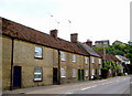
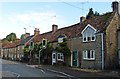
Terraced houses North Street Crewkerne
These houses are close to the junction of Ashlands Road with North Street. The modern houses of Ashlands Close are just visible over the rooftops on the right.
Image: © Sarah Smith
Taken: 28 May 2009
0.13 miles
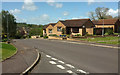
10
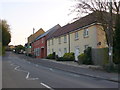
New Houses on North St.
North St becomes the Broadshard Rd at about this point. It is also the A356, the main road out of the town to the north and the A303.
Image: © Nigel Mykura
Taken: 2 May 2013
0.15 miles