IMAGES TAKEN NEAR TO
North Street, CREWKERNE, TA18 7BL
Introduction
This page details the photographs taken nearby to North Street, TA18 7BL by members of the Geograph project.
The Geograph project started in 2005 with the aim of publishing, organising and preserving representative images for every square kilometre of Great Britain, Ireland and the Isle of Man.

There are currently over 7.5m images from over14,400 individuals and you can help contribute to the project by visiting https://www.geograph.org.uk
Image Map
Images are licensed for reuse under creativecommons.org/licenses/by-sa/2.0
Notes
- Clicking on the map will re-center to the selected point.
- The higher the marker number, the further away the image location is from the centre of the postcode.
Image Listing (233 Images Found)
Images are licensed for reuse under creativecommons.org/licenses/by-sa/2.0
Image
Details
Distance
2
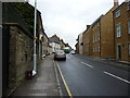
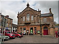
Behind the Town Hall Crewkerne
The cars from North Street whizz past the Georgian houses on the north side of Market Square. No longer lived in the buildings are now used as offices. On the right is the back of the Town Hall. Notice the matching door and telephone box.
Image: © Sarah Smith
Taken: 28 May 2009
0.04 miles

4
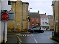
Abbey St Crewkerne
Abbey St runs from the junction of Pople's Well and Rose Lane to its junction with North St. This shows the stop sign at the North St junction with the two pre-Worboys signs on the wall to Ilminster and Ilchester on the A356
Image: © Nigel Mykura
Taken: 13 Dec 2016
0.04 miles
5
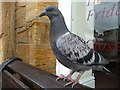
Crewkerne : Pigeon
A pigeon is sitting outside the town hall of Crewkerne.
Image: © Lewis Clarke
Taken: 14 Apr 2009
0.05 miles
6
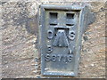
Ordnance Survey Flush Bracket S6716
This can be found on the wall of the Town Hall, Crewkerne.
For more detail see : http://www.bench-marks.org.uk/bm260
Image: © Peter Wood
Taken: 1 Apr 2014
0.05 miles
8
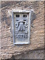
Ordnance Survey Flush Bracket (S6716)
This OS Flush Bracket can be found on the west face of the Victoria Hall. It marks a point 70.578m above mean sea level.
Image: © Adrian Dust
Taken: 29 Mar 2015
0.05 miles
9
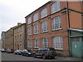
Old Clothing Factory Crewkerne
Old Bonsoir nightware factory. Planning permission being sought to convert to flats.
Image: © Andrew Davis
Taken: 31 Jan 2011
0.05 miles
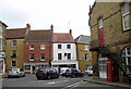
10
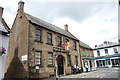
The King's Arms, Crewkerne
One of several coaching inns in the town centre. Grade-II listed (ref. 1202972): https://www.britishlistedbuildings.co.uk/101202972-kings-arms-public-house-crewkerne#.WjmLpCZLGAg .
Image: © Bill Harrison
Taken: 11 Jul 2016
0.05 miles