IMAGES TAKEN NEAR TO
Sherlands, MERRIOTT, TA16 5RD
Introduction
This page details the photographs taken nearby to Sherlands, TA16 5RD by members of the Geograph project.
The Geograph project started in 2005 with the aim of publishing, organising and preserving representative images for every square kilometre of Great Britain, Ireland and the Isle of Man.

There are currently over 7.5m images from over14,400 individuals and you can help contribute to the project by visiting https://www.geograph.org.uk
Image Map (Loading...)


Getting Data...Please wait
Leaflet Map data © OpenStreetMap
Images are licensed for reuse under creativecommons.org/licenses/by-sa/2.0
Notes
- Clicking on the map will re-center to the selected point.
- The higher the marker number, the further away the image location is from the centre of the postcode.
Image Listing (19 Images Found)
Images are licensed for reuse under creativecommons.org/licenses/by-sa/2.0
Image
Details
Distance
3
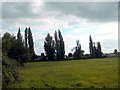
Enclosed meadow - Merriott
Looking over a gate in Church Street across the meadow towards Sherlands. The gridline cuts across the left hand corner of the field. This is some of what remains of the land which was communally farmed before 1066 in the centre of the village and is the reason for the triangular shape of the original community. Much of the land has now been built over with housing.
Image: © Sarah Smith
Taken: 13 Sep 2009
0.13 miles
4
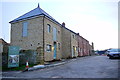
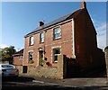
Moorlands Farm Merriot
This was once a large working farm but now the buildings have been converted to residential use and some extra houses have been built on the farmyard.
Image: © Nigel Mykura
Taken: 30 Jan 2016
0.16 miles
5
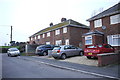
Newcastle Crescent.
These small terraces are in a very short residential road that links Church St and Broadway in Merriot very close to the intersection of the two streets.
Image: © Nigel Mykura
Taken: 30 Jan 2016
0.16 miles
6
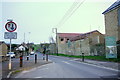
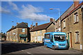
Broadway Merriot
This is the main road through the village. On the right is Moorlands Farm which is being developed into a small housing estate with a mix of new build and barn conversions from the old farm buildings. The road has significant traffic calming measures because previously it was a fast straight road.
Image: © Nigel Mykura
Taken: 30 Jan 2016
0.19 miles
7
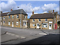
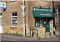
Post Office, Merriott, Somerset
located at 1 Knapp, the crossroads which links Broadway (left) and Lower Street in the south of the village and square.
Image: © Rodney Burton
Taken: 2 Mar 2006
0.19 miles