IMAGES TAKEN NEAR TO
Bakers Close, TAUNTON, TA1 5HD
Introduction
This page details the photographs taken nearby to Bakers Close, TA1 5HD by members of the Geograph project.
The Geograph project started in 2005 with the aim of publishing, organising and preserving representative images for every square kilometre of Great Britain, Ireland and the Isle of Man.

There are currently over 7.5m images from over14,400 individuals and you can help contribute to the project by visiting https://www.geograph.org.uk
Image Map
Images are licensed for reuse under creativecommons.org/licenses/by-sa/2.0
Notes
- Clicking on the map will re-center to the selected point.
- The higher the marker number, the further away the image location is from the centre of the postcode.
Image Listing (22 Images Found)
Images are licensed for reuse under creativecommons.org/licenses/by-sa/2.0
Image
Details
Distance
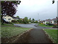
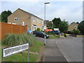
2
Bishops Hull Road, Bishops Hull, Taunton
Image: © David Smith
Taken: 18 Oct 2017
0.07 miles
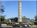
4
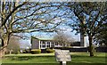
Taunton : Crematorium
Taunton Crematorium
Image: © Lewis Clarke
Taken: 28 Sep 2005
0.13 miles
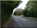
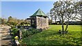
5
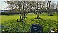
Taunton Crematorium Garden Of Rest
A lovely looking spot to remember the departed.
Image: © Steve Barnes
Taken: 21 Apr 2021
0.15 miles
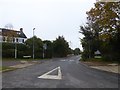
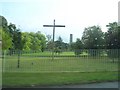
6
Taunton Deane Crematorium
Situated on the A38 (Wellington New Road) near Taunton town centre, this photo shows the chapel and tall chimney. A wooden cross can just be seen on the left of the photo. Its postcode is TA1 5NE.
Image: © David Hillas
Taken: 30 Sep 2011
0.15 miles
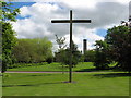
9
Taunton Crematorium Chapel Of Rest
Behind the crematoriums main building
Image: © Steve Barnes
Taken: 21 Apr 2021
0.17 miles