IMAGES TAKEN NEAR TO
Longmead Close, TAUNTON, TA1 4SZ
Introduction
This page details the photographs taken nearby to Longmead Close, TA1 4SZ by members of the Geograph project.
The Geograph project started in 2005 with the aim of publishing, organising and preserving representative images for every square kilometre of Great Britain, Ireland and the Isle of Man.

There are currently over 7.5m images from over14,400 individuals and you can help contribute to the project by visiting https://www.geograph.org.uk
Image Map
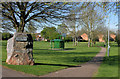
Images are licensed for reuse under creativecommons.org/licenses/by-sa/2.0
Notes
- Clicking on the map will re-center to the selected point.
- The higher the marker number, the further away the image location is from the centre of the postcode.
Image Listing (31 Images Found)
Images are licensed for reuse under creativecommons.org/licenses/by-sa/2.0
Image
Details
Distance
1
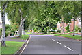
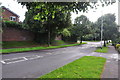
Taunton : Parkfield Road
Looking up Parkfield Road from Galmington Road.
Image: © Lewis Clarke
Taken: 23 Aug 2015
0.12 miles
2
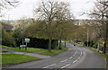
Galmington Road - Taunton
Until just after the war this used to be a narrow lane that ended at a ford along the river.
Image: © Nick Chipchase
Taken: 13 Apr 2009
0.12 miles
3
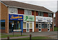
Galmington Road
Chip shop and Dry Cleaners.
Image: © Nick Chipchase
Taken: 23 Mar 2009
0.13 miles
4
Taunton : Galmington Road
Looking along Galmington Road in the Taunton suburbs.
Image: © Lewis Clarke
Taken: 23 Aug 2015
0.13 miles
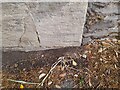
5
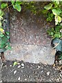
Ordnance Survey Cut Mark
This mostly buried OS cut mark can be found on the mile stone east side of Trull Road. It marks a point 45.450m above mean sea level. https://www.geograph.org.uk/photo/7540146
Image: © Adrian Dust
Taken: 12 Jul 2023
0.13 miles
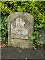
6
Milestone - Market House, Taunton 1
There is an Ordnance Survey cut mark on the front of the stone. https://www.geograph.org.uk/photo/7540143
Image: © Adrian Dust
Taken: 12 Jul 2023
0.13 miles
7
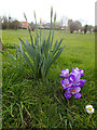
Springtime At Galmington
View across Comeytrowe playing fields from College Way.
Image: © Nick Chipchase
Taken: 5 Mar 2015
0.14 miles
8
Old Milestone by Trull Road, Haines Hill, Taunton parish
Metal plate attached to stone post by the UC road, in parish of TAUNTON (TAUNTON DEANE District), Trull Road, Haines Hill, by No. 51, 50m North of Sherford Road junction, back of pavement under hedge, just past "Holly House", on East side of road. Taunton roll top iron plate erected by the Taunton turnpike trust in the 19th century.
Inscription reads:-
1
MILE
To
Taunton
Carved benchmark on lower front face (almost hidden by tarmac).
Grade II listed.
List Entry Number: 1386068 https://historicengland.org.uk/listing/the-list/list-entry/1386068
Milestone Society National ID: SO_TATL01
Image: © Alan Rosevear
Taken: 8 Jun 2012
0.14 miles
9
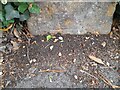
Ordnance Survey Cut Mark
This almost buried OS cut mark can be found on the stone gatepost east side of Trull Road. It marks a point 45.912m above mean sea level.
Image: © Adrian Dust
Taken: 12 Jul 2023
0.14 miles