IMAGES TAKEN NEAR TO
Parkfield Road, TAUNTON, TA1 4SF
Introduction
This page details the photographs taken nearby to Parkfield Road, TA1 4SF by members of the Geograph project.
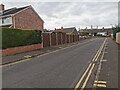
The Geograph project started in 2005 with the aim of publishing, organising and preserving representative images for every square kilometre of Great Britain, Ireland and the Isle of Man.

There are currently over 7.5m images from over14,400 individuals and you can help contribute to the project by visiting https://www.geograph.org.uk
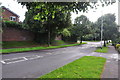
Image Map
Images are licensed for reuse under creativecommons.org/licenses/by-sa/2.0
Notes
- Clicking on the map will re-center to the selected point.
- The higher the marker number, the further away the image location is from the centre of the postcode.
Image Listing (41 Images Found)
Images are licensed for reuse under creativecommons.org/licenses/by-sa/2.0
Image
Details
Distance
2
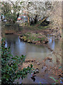
Footpath along the steam by the hospital
Image: © Nick Chipchase
Taken: 13 Apr 2009
0.13 miles
3
Tangier, Taunton
The confluence of the two rivers.
Image: © Nick Chipchase
Taken: 9 Mar 2009
0.15 miles
4
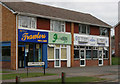
Galmington Road
Chip shop and Dry Cleaners.
Image: © Nick Chipchase
Taken: 23 Mar 2009
0.15 miles
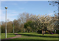
6
Taunton : Manor Orchard
A road off Parkfield Drive.
Image: © Lewis Clarke
Taken: 13 Aug 2021
0.15 miles
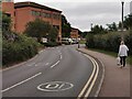
7
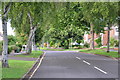
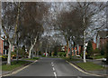
Taunton : Parkfield Road
Looking up Parkfield Road from Galmington Road.
Image: © Lewis Clarke
Taken: 23 Aug 2015
0.16 miles
8
Galmington Road - Taunton
Until just after the war this used to be a narrow lane that ended at a ford along the river.
Image: © Nick Chipchase
Taken: 13 Apr 2009
0.16 miles
9
Taunton : Galmington Road
Looking along Galmington Road in the Taunton suburbs.
Image: © Lewis Clarke
Taken: 23 Aug 2015
0.16 miles
10
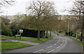
Taunton : Musgrove Park Hospital
A road heads around the hospital.
Image: © Lewis Clarke
Taken: 18 Aug 2021
0.16 miles