IMAGES TAKEN NEAR TO
East Stoke, STOKE-SUB-HAMDON, TA14 6UQ
Introduction
This page details the photographs taken nearby to TA14 6UQ by members of the Geograph project.
The Geograph project started in 2005 with the aim of publishing, organising and preserving representative images for every square kilometre of Great Britain, Ireland and the Isle of Man.

There are currently over 7.5m images from over14,400 individuals and you can help contribute to the project by visiting https://www.geograph.org.uk
Image Map
Images are licensed for reuse under creativecommons.org/licenses/by-sa/2.0
Notes
- Clicking on the map will re-center to the selected point.
- The higher the marker number, the further away the image location is from the centre of the postcode.
Image Listing (11 Images Found)
Images are licensed for reuse under creativecommons.org/licenses/by-sa/2.0
Image
Details
Distance
1
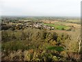
Looking down towards East Stoke
From the top of St Michaels Tower.
Image: © Roger Cornfoot
Taken: 1 Nov 2017
0.05 miles
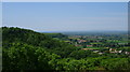
2
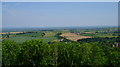
Somerset in all its glory from St Michaels Hill
Yes there were some blue skies in the summer of 2008!
Image: © David Robinson
Taken: 9 Jun 2008
0.05 miles
5

Sports Centre
The sports centre at Stanchester School.
Image: © Andy Pearce
Taken: 17 Feb 2008
0.14 miles
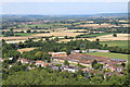
6
Hedgecock Hill Woods from St Michael's Hill
East Stoke Church is also visible
Image: © David Robinson
Taken: 9 Jun 2008
0.16 miles
7
View looking north from the side of St Michael's Hill
Image: © Rob Purvis
Taken: 31 Aug 2019
0.17 miles
8
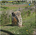
Old Milestone on Montacute Road
Stone post (plate lost) by the UC road (was A3088), in parish of Montacute (South Somerset District), Montacute Road, beside allotment gardens, north of St Michael's Hill, on grass verge in front of chain link fence, on the north side of the road. Ilminster iron plate erected by the Ilminster turnpike trust in the 19th century.
Inscription reads:- (ILMINSTER / 9 /) and (YEOVIL / 4½ / ).
Carved benchmark on lower right side.
Somerset HER number: 14320 https://www.somersetheritage.org.uk/record/14320
Milestone Society National ID: SO_IMYV09.
Image: © Alan Rosevear
Taken: 12 Apr 2011
0.20 miles
9
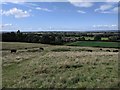
The western edge of Montacute village
On the left is a large area of allotments
Image: © David Smith
Taken: 2 Oct 2014
0.21 miles
10
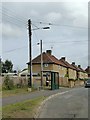
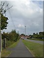
Bus shelter on the edge of Montacute village
Image: © David Smith
Taken: 2 Oct 2014
0.24 miles