IMAGES TAKEN NEAR TO
Norton Sub Hamdon, STOKE-SUB-HAMDON, TA14 6TF
Introduction
This page details the photographs taken nearby to TA14 6TF by members of the Geograph project.
The Geograph project started in 2005 with the aim of publishing, organising and preserving representative images for every square kilometre of Great Britain, Ireland and the Isle of Man.

There are currently over 7.5m images from over14,400 individuals and you can help contribute to the project by visiting https://www.geograph.org.uk
Image Map (Loading...)


Getting Data...Please wait
Leaflet Map data © OpenStreetMap
Images are licensed for reuse under creativecommons.org/licenses/by-sa/2.0
Notes
- Clicking on the map will re-center to the selected point.
- The higher the marker number, the further away the image location is from the centre of the postcode.
Image Listing (9 Images Found)
Images are licensed for reuse under creativecommons.org/licenses/by-sa/2.0
Image
Details
Distance
2
Tinkers Bubble
This small waterfall on a brook at the side of the road is known as Tinkers Bubble and was known as the place where gypsies watered their horses. Tinkers Bubble is now actually more famous as the name of a nearby off grid eco friendly community which took its name from this waterfall.
Image: © Nigel Mykura
Taken: 30 Jan 2016
0.13 miles
4
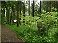
Tinkers' Bubble, Norton Covert
Tinkers' Bubble is an eco-friendly communal settlement, set in a small off-grid hillside woodland community on 40 acres (16 hectares) of land in rural Somerset, England. The residents, known as Bubbleites, manage the land without fossil fuels, and have been for the last twenty years making a living mainly through forestry, apple products and gardening. As a result they say they are money poor but happiness rich.
The name Tinkers Bubble comes from the spring that flows through the woodland ending in a small waterfall by the road. This is where gypsies brought their horses to water them at the bubble; the gypsy name for a waterfall.
Image: © Becky Williamson
Taken: 22 May 2015
0.20 miles


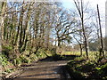
7
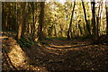
Norton Covert
The Liberty Trail rises steeply up through Norton Covert.
Image: © Andy Pearce
Taken: 12 Nov 2008
0.21 miles
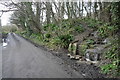
8
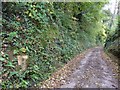
Benchmark on roadside stone, near Westbury Farm
Ordnance Survey benchmark on minor road near Westbury Farm, Little Norton in Somerset. Someone had obviously been before us and cleared away the vegetation so that this benchmark was visible. For description on database, see http://www.bench-marks.org.uk/bm71315. See also
Image: © Becky Williamson
Taken: 23 Oct 2015
0.23 miles
9
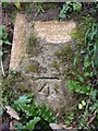
Benchmark on roadside stone, near Westbury Farm
Ordnance Survey benchmark, described on database at http://www.bench-marks.org.uk/bm71315. See also
Image: © Becky Williamson
Taken: 23 Oct 2015
0.23 miles