IMAGES TAKEN NEAR TO
Glebelands, STOKE-SUB-HAMDON, TA14 6SD
Introduction
This page details the photographs taken nearby to Glebelands, TA14 6SD by members of the Geograph project.
The Geograph project started in 2005 with the aim of publishing, organising and preserving representative images for every square kilometre of Great Britain, Ireland and the Isle of Man.

There are currently over 7.5m images from over14,400 individuals and you can help contribute to the project by visiting https://www.geograph.org.uk
Image Map
Images are licensed for reuse under creativecommons.org/licenses/by-sa/2.0
Notes
- Clicking on the map will re-center to the selected point.
- The higher the marker number, the further away the image location is from the centre of the postcode.
Image Listing (83 Images Found)
Images are licensed for reuse under creativecommons.org/licenses/by-sa/2.0
Image
Details
Distance
1
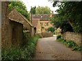
Rectory Lane, Norton Sub Hamdon
Approaching Mill Farm along the winding lane, which, as it passes the farm in the background, becomes a bridleway and moves out of the square.
Image: © Derek Harper
Taken: 15 Sep 2009
0.04 miles
3
Footpath sign north of Norton Sub Hamdon
A footpath, Y 20/26, leaves the bridleway which continues the line of Rectory Lane. The signpost, in case you were interested, is feature 14902.
Image: © Derek Harper
Taken: 15 Sep 2009
0.05 miles
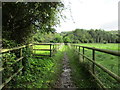
4
Footbridge over a tributary of the River Parrett
Image: © Jonathan Thacker
Taken: 14 Sep 2017
0.05 miles
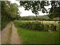
6
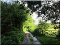
Bridleway to Stoke sub Hamdon
A continuation of Rectory Lane.
Image: © Jonathan Thacker
Taken: 14 Sep 2017
0.07 miles
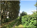
7
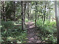
Pathway through Gross' Wood
Gross' Wood is a community woodland planted in 1998.
Image: © Jonathan Thacker
Taken: 14 Sep 2017
0.08 miles
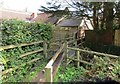
8
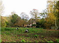
Over the churchyard wall - Norton sub Hamdon
Two Saddleback pigs enjoying rooting about the rich earth of their field. The soil was flying out of the holes they were digging with their snouts. Behind is a delightful view of an old village house.
Image: © Sarah Smith
Taken: 31 Oct 2009
0.08 miles
9
Poplars by a footpath, Norton sub Hamdon
Image: © Jonathan Thacker
Taken: 14 Sep 2017
0.09 miles
10

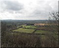
Fields near Norton sub Hamdon
Looking SW towards Norton from the Norton car park on top of Ham Hill. The church at Norton which is just in ST4715 can be seen in the distance.
Image: © Nigel Mykura
Taken: 28 Jun 2008
0.09 miles