IMAGES TAKEN NEAR TO
High Street, STOKE-SUB-HAMDON, TA14 6PP
Introduction
This page details the photographs taken nearby to High Street, TA14 6PP by members of the Geograph project.
The Geograph project started in 2005 with the aim of publishing, organising and preserving representative images for every square kilometre of Great Britain, Ireland and the Isle of Man.

There are currently over 7.5m images from over14,400 individuals and you can help contribute to the project by visiting https://www.geograph.org.uk
Image Map
Images are licensed for reuse under creativecommons.org/licenses/by-sa/2.0
Notes
- Clicking on the map will re-center to the selected point.
- The higher the marker number, the further away the image location is from the centre of the postcode.
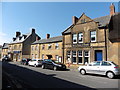
Image Listing (70 Images Found)
Images are licensed for reuse under creativecommons.org/licenses/by-sa/2.0
Image
Details
Distance
1
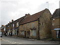
Derelict cottages facing down North Street
These stand at the junction of North, West and High Streets.
Image: © Jonathan Thacker
Taken: 14 Sep 2017
0.01 miles
3
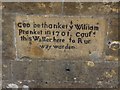
Pranket's Well, Stoke Sub Hamdon
Plaque on Pranket's Well.
Until the early C20 there was no mains water supply in the village of Stoke Sub Hamdon. While some houses had wells the majority would have to queue to use Pranket's well, supplied by surface water from Hamdon Hill. The stone from which the conduit opened was inscribed "God be thanket, William Prankett, in 1701, caused this water here to run".
A Dr Stanley Brimblecome in the first half of the C20 analysed the water and found it to contain potentially dangerous impurities, providing the impetus for a mains water supply. (Info from somerset.gov.uk)
Image: © Becky Williamson
Taken: 22 May 2015
0.03 miles
4
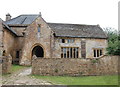
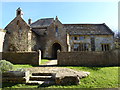
Parsonage Farmhouse (the Priory), Stoke Sub Hamdon
Originally a chantry college established in the 14th Century and Grade-I listed: http://www.britishlistedbuildings.co.uk/en-441493-parsonage-farmhouse-the-priory-stoke-sub#.V79L-iZTGmQ . The Ham stone comes from Ham Hill, just a kilometre away.
Image: © Bill Harrison
Taken: 7 Jul 2016
0.04 miles
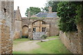
5
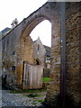
Priory gateway - Stoke sub Hamdon
Through the massive gateway one catches a glimpse of the 14th century Priest's House.
Image: © Sarah Smith
Taken: 24 Oct 2009
0.05 miles
6
The old hall of the Priory in Stoke-sub-Hampden
Image: © Sarah Charlesworth
Taken: 12 Apr 2016
0.05 miles
7
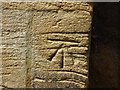
Benchmark on Grain Cottage, Stoke Sub Hamdon
Ordnance Survey benchmark, described on database at http://www.bench-marks.org.uk/bm50629.
Image: © Becky Williamson
Taken: 22 May 2015
0.05 miles
8
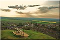
Stoke-sub-Hamdon: View from Ham Hill
A superb view of the village below from a park bench.
Image: © Mr Eugene Birchall
Taken: 3 May 2010
0.05 miles
9
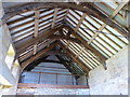
The roof of the old priory hall in Stoke-sub-Hampden
Image: © Sarah Charlesworth
Taken: 12 Apr 2016
0.05 miles
10
Gateway to Parsonage farmyard, Stoke Sub Hamdon
Image: © Bill Harrison
Taken: 7 Jul 2016
0.05 miles