IMAGES TAKEN NEAR TO
Mountfields Road, TAUNTON, TA1 3DG
Introduction
This page details the photographs taken nearby to Mountfields Road, TA1 3DG by members of the Geograph project.
The Geograph project started in 2005 with the aim of publishing, organising and preserving representative images for every square kilometre of Great Britain, Ireland and the Isle of Man.

There are currently over 7.5m images from over14,400 individuals and you can help contribute to the project by visiting https://www.geograph.org.uk
Image Map (Loading...)


Getting Data...Please wait
Leaflet Map data © OpenStreetMap
Images are licensed for reuse under creativecommons.org/licenses/by-sa/2.0
Notes
- Clicking on the map will re-center to the selected point.
- The higher the marker number, the further away the image location is from the centre of the postcode.
Image Listing (13 Images Found)
Images are licensed for reuse under creativecommons.org/licenses/by-sa/2.0
Image
Details
Distance
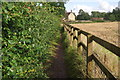
1
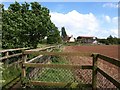
Approaching Pool Farm
Pool Farm sits in almost level land near the Stockwell Stream south of Taunton. T 26/2 makes a double bend as it runs between farmland and a sports field (left).
Image: © Derek Harper
Taken: 16 May 2009
0.03 miles
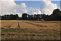
2
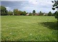
Running track, Wyvern Club
From the path shown in Image, a view across the corner of a sports field. On the far side flows the Stockwell Stream, with buildings of the Wyvern Club.
Image: © Derek Harper
Taken: 16 May 2009
0.05 miles
3
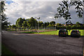
Taunton : Wyvern Club Car Park
A car park at the Wyvern Club.
Image: © Lewis Clarke
Taken: 23 Aug 2015
0.09 miles
4
Taunton : Bishop Fox's Community School
Looking towards the grounds of the community school during the summer holidays.
Image: © Lewis Clarke
Taken: 23 Aug 2015
0.09 miles
5
Taunton : Footpath
A footpath heading towards Pool Farm in Taunton.
Image: © Lewis Clarke
Taken: 23 Aug 2015
0.09 miles
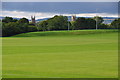
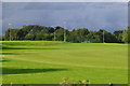
6
Taunton : Grassy Field
A grassy field on the Taunton outskirts.
Image: © Lewis Clarke
Taken: 23 Aug 2015
0.10 miles
7
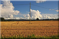
Taunton : Grassy Field
Looking towards a telegraph pole in the field.
Image: © Lewis Clarke
Taken: 23 Aug 2015
0.11 miles
8
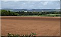
Field south of Taunton
A field ready for cultivation with a good view of the skyline of Taunton and the Quantocks beyond.
Image: © Derek Harper
Taken: 16 May 2009
0.17 miles
9
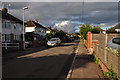
Taunton : Mountfields Road
A small residential road in the Taunton suburbs.
Image: © Lewis Clarke
Taken: 23 Aug 2015
0.17 miles
10
Taunton : Bishop Fox's Community School
A wide expansive field on the school's property.
Image: © Lewis Clarke
Taken: 23 Aug 2015
0.18 miles