IMAGES TAKEN NEAR TO
Shoreditch Road, TAUNTON, TA1 3DF
Introduction
This page details the photographs taken nearby to Shoreditch Road, TA1 3DF by members of the Geograph project.
The Geograph project started in 2005 with the aim of publishing, organising and preserving representative images for every square kilometre of Great Britain, Ireland and the Isle of Man.

There are currently over 7.5m images from over14,400 individuals and you can help contribute to the project by visiting https://www.geograph.org.uk
Image Map
Images are licensed for reuse under creativecommons.org/licenses/by-sa/2.0
Notes
- Clicking on the map will re-center to the selected point.
- The higher the marker number, the further away the image location is from the centre of the postcode.
Image Listing (18 Images Found)
Images are licensed for reuse under creativecommons.org/licenses/by-sa/2.0
Image
Details
Distance
1
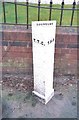
Old Boundary Marker by the B3170, Shoreditch Road, Taunton
Municipal Boundary Marker by the B3170, in parish of Taunton (Taunton Deane District), Shoreditch Road, South of Fullands Road, against garden wall, East side of road.
Inscription reads:-
: T.T.C. : : BOUNDARY : : T.H.B. :
(Taunton Town Council and Taunton Highways Board)
Grade II listed.
List Entry Number: 1392990 https://historicengland.org.uk/listing/the-list/list-entry/1392990
Surveyed
Milestone Society National ID: SO_TAUHB01pb
Image: © Milestone Society
Taken: Unknown
0.05 miles
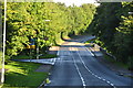
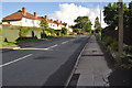
2
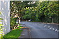
Taunton : Shoreditch Road B3170
Looking along the road as it heads out of Taunton.
Image: © Lewis Clarke
Taken: 23 Aug 2015
0.06 miles
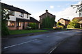
3
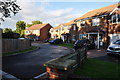
Taunton : The Laurels
Looking along the Laurels and the houses alongside it.
Image: © Lewis Clarke
Taken: 23 Aug 2015
0.07 miles
4
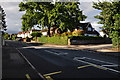
Taunton : Shoreditch Road B3170
A road heading through the Taunton suburbs.
Image: © Lewis Clarke
Taken: 23 Aug 2015
0.11 miles
5
Taunton : Shoreditch Road B3170
A road heading out of Taunton.
Image: © Lewis Clarke
Taken: 23 Aug 2015
0.12 miles
6
Taunton : Killams Crescent
Looking along Killams Crescent in Taunton.
Image: © Lewis Clarke
Taken: 23 Aug 2015
0.14 miles
7
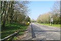
Shoreditch Road
Very suburban, now that Taunton has spread out to the M5.
Image: © Richard Webb
Taken: 9 Apr 2015
0.17 miles
8
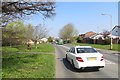
Chestnut Drive
A distribution road in the suburbs of Taunton. Heading towards Holway.
Image: © Richard Webb
Taken: 9 Apr 2015
0.20 miles
9
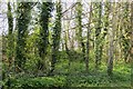
Woodland, Shoreditch Road
The wood is now surrounded by the suburbs of Taunton.
Image: © Richard Webb
Taken: 9 Apr 2015
0.20 miles
10
Taunton : Shoreditch Road B3170
Heading along a road which heads through the Taunton suburbs.
Image: © Lewis Clarke
Taken: 23 Aug 2015
0.20 miles