Old Boundary Marker by the B3170, Shoreditch Road, Taunton
Introduction
The photograph on this page of Old Boundary Marker by the B3170, Shoreditch Road, Taunton by Milestone Society as part of the Geograph project.
The Geograph project started in 2005 with the aim of publishing, organising and preserving representative images for every square kilometre of Great Britain, Ireland and the Isle of Man.

There are currently over 7.5m images from over 14,400 individuals and you can help contribute to the project by visiting https://www.geograph.org.uk
Old Boundary Marker by the B3170, Shoreditch Road, Taunton
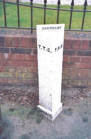
Image: © Milestone Society Taken: Unknown
Municipal Boundary Marker by the B3170, in parish of Taunton (Taunton Deane District), Shoreditch Road, South of Fullands Road, against garden wall, East side of road. Inscription reads:- : T.T.C. : : BOUNDARY : : T.H.B. : (Taunton Town Council and Taunton Highways Board) Grade II listed. List Entry Number: 1392990 https://historicengland.org.uk/listing/the-list/list-entry/1392990 Surveyed Milestone Society National ID: SO_TAUHB01pb
Images are licensed for reuse under creativecommons.org/licenses/by-sa/2.0
Image Location
Latitude
51.001518
Longitude
-3.086776