IMAGES TAKEN NEAR TO
Shoreditch Road, TAUNTON, TA1 3BU
Introduction
This page details the photographs taken nearby to Shoreditch Road, TA1 3BU by members of the Geograph project.
The Geograph project started in 2005 with the aim of publishing, organising and preserving representative images for every square kilometre of Great Britain, Ireland and the Isle of Man.

There are currently over 7.5m images from over14,400 individuals and you can help contribute to the project by visiting https://www.geograph.org.uk
Image Map
Images are licensed for reuse under creativecommons.org/licenses/by-sa/2.0
Notes
- Clicking on the map will re-center to the selected point.
- The higher the marker number, the further away the image location is from the centre of the postcode.
Image Listing (12 Images Found)
Images are licensed for reuse under creativecommons.org/licenses/by-sa/2.0
Image
Details
Distance
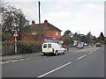
1
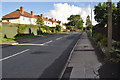
Taunton : Shoreditch Road B3170
Heading along a road which heads through the Taunton suburbs.
Image: © Lewis Clarke
Taken: 23 Aug 2015
0.04 miles
2
Taunton : Shoreditch Road B3170
A road heading through the Taunton suburbs.
Image: © Lewis Clarke
Taken: 23 Aug 2015
0.07 miles
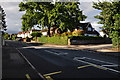
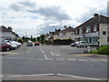
4
Taunton : South Road B3170
Looking along the road as it heads through Taunton.
Image: © Lewis Clarke
Taken: 23 Aug 2015
0.10 miles
5
One-Stop shop and post office, South Road, Taunton
Image: © Roger Cornfoot
Taken: 9 Jan 2013
0.12 miles
6
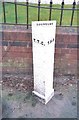
Old Boundary Marker by the B3170, Shoreditch Road, Taunton
Municipal Boundary Marker by the B3170, in parish of Taunton (Taunton Deane District), Shoreditch Road, South of Fullands Road, against garden wall, East side of road.
Inscription reads:-
: T.T.C. : : BOUNDARY : : T.H.B. :
(Taunton Town Council and Taunton Highways Board)
Grade II listed.
List Entry Number: 1392990 https://historicengland.org.uk/listing/the-list/list-entry/1392990
Surveyed
Milestone Society National ID: SO_TAUHB01pb
Image: © Milestone Society
Taken: Unknown
0.13 miles
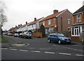
7
Taunton : Mountfields Road
Mountfields Road in Taunton with services Kingfisher Veterinary Practice and Whyman House Dental Practice.
Image: © Lewis Clarke
Taken: 17 Jun 2008
0.14 miles
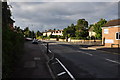
8
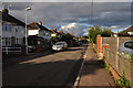
Taunton : Mountfields Road
A small residential road in the Taunton suburbs.
Image: © Lewis Clarke
Taken: 23 Aug 2015
0.17 miles
9
Chestnut Drive
A distribution road in the suburbs of Taunton. Heading towards Holway.
Image: © Richard Webb
Taken: 9 Apr 2015
0.22 miles
10

Taunton : Grassy Field
Looking towards a telegraph pole in the field.
Image: © Lewis Clarke
Taken: 23 Aug 2015
0.23 miles