IMAGES TAKEN NEAR TO
Lopen, SOUTH PETHERTON, TA13 5JN
Introduction
This page details the photographs taken nearby to TA13 5JN by members of the Geograph project.
The Geograph project started in 2005 with the aim of publishing, organising and preserving representative images for every square kilometre of Great Britain, Ireland and the Isle of Man.

There are currently over 7.5m images from over14,400 individuals and you can help contribute to the project by visiting https://www.geograph.org.uk
Image Map
Images are licensed for reuse under creativecommons.org/licenses/by-sa/2.0
Notes
- Clicking on the map will re-center to the selected point.
- The higher the marker number, the further away the image location is from the centre of the postcode.
Image Listing (13 Images Found)
Images are licensed for reuse under creativecommons.org/licenses/by-sa/2.0
Image
Details
Distance
1
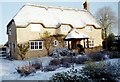
A Lopen house in winter
Winter casts its magic on this house in Lopen Somerset
Image: © Michael Canton
Taken: Unknown
0.07 miles
2
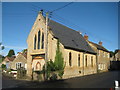
Former chapel in Lopen
Now a house.
Image: © Jonathan Thacker
Taken: 15 Sep 2017
0.18 miles
3
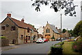
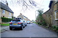
Holloway Road, Lopen
The main road through the village with a converted chapel visible.
Image: © Bill Harrison
Taken: 15 Jul 2016
0.19 miles
4
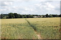
Footpath to Lopen
Manor Farm is visible in the distance.
Image: © Bill Harrison
Taken: 6 Jul 2016
0.20 miles
5
Church St Lopen
This is a dead end . The street winds past the village church and then becomes Rydon lane for a hundred metres or so and then terminates in some fields.
Image: © Nigel Mykura
Taken: 30 Jan 2016
0.20 miles
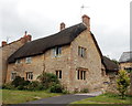
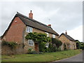
6
Lopen Farmhouse, Church Street, Lopen
This is the 'fanciest' farmhouse in the village with its ashlar façade and Doric porch. Grade-II listed: http://www.britishlistedbuildings.co.uk/101177528-lopen-farmhouse-and-front-boundary-railings-lopen#.WYYRdiaWyAg .
Image: © Bill Harrison
Taken: 15 Jul 2016
0.21 miles
7
The Wilderness, Church Street, Lopen
The oldest parts date from the seventeenth century https://historicengland.org.uk/listing/the-list/list-entry/1307459
Image: © Jonathan Thacker
Taken: 15 Sep 2017
0.21 miles
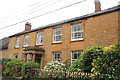
8
Cottage, Church Street, Lopen
This 17th Century Grade-II (see: http://www.britishlistedbuildings.co.uk/101307459-the-wilderness-lopen#.WYYQjiaWyAg ) cottage with some fine mullioned widows has the interesting name of the Wilderness, although it looks anything but. At some point it lost its door at the front.
Image: © Bill Harrison
Taken: 15 Jul 2016
0.21 miles
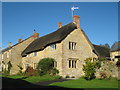
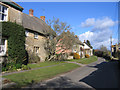
9
Thatched cottages, Church Street, Lopen
To the left, The Old Bailiff's Cottage, to the right, Little Cottage. The latter has been recently extended and the former lean-to beautifully converted into the bay nearest the camera (compare the Google Earth street-view image from 2009). Both cottages are Grade-II listed.
Image: © Bill Harrison
Taken: 15 Jul 2016
0.22 miles
10
Cottages, Church Street, Lopen, Somerset
– view NE.
Image: © Rodney Burton
Taken: 28 Feb 2006
0.22 miles