IMAGES TAKEN NEAR TO
Barle Close, TAUNTON, TA1 2NY
Introduction
This page details the photographs taken nearby to Barle Close, TA1 2NY by members of the Geograph project.
The Geograph project started in 2005 with the aim of publishing, organising and preserving representative images for every square kilometre of Great Britain, Ireland and the Isle of Man.

There are currently over 7.5m images from over14,400 individuals and you can help contribute to the project by visiting https://www.geograph.org.uk
Image Map (Loading...)


Getting Data...Please wait
Leaflet Map data © OpenStreetMap
Images are licensed for reuse under creativecommons.org/licenses/by-sa/2.0
Notes
- Clicking on the map will re-center to the selected point.
- The higher the marker number, the further away the image location is from the centre of the postcode.
Image Listing (15 Images Found)
Images are licensed for reuse under creativecommons.org/licenses/by-sa/2.0
Image
Details
Distance
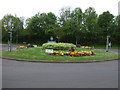
1
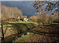
The Black Brook
The brook flows through the Blackbrook Open Space, an important wildlife corridor through the large housing estate in south-east Taunton.
Image: © Derek Harper
Taken: 9 Feb 2010
0.08 miles
2
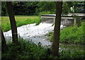
Sump in the Blackbrook Stream
Sump in the Blackbrook Stream Taunton, part of the storm drainage system.
Image: © Julie Munckton
Taken: 20 May 2007
0.12 miles
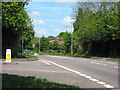
3
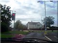
Taunton : Traffic Lights on Illminster Road
Waiting at the traffic lights on Illminster Road into Bridgwater Road and Hamilton Road
Image: © Lewis Clarke
Taken: 11 Oct 2006
0.18 miles
4
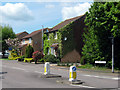
Calder Crescent at junction with Blackbrook Way, Taunton
Image: © Ken Grainger
Taken: 10 May 2010
0.18 miles
5
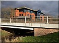
NHS South West offices
A new building on Blackbrook Business Park between Blackbrook Way (foreground) and Blackbrook Park Avenue, with the Black Brook itself on the left.
Image: © Derek Harper
Taken: 9 Feb 2010
0.19 miles
7
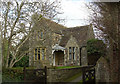
Old Toll House, Taunton
Toll House in the parish of Taunton, The Old Turnpike, Bridgwater Road, TA1.
From Somerset Historic Environment Record:-
"The building has been constructed c.1929 with materials from the toll house at Halcon Corner"
Somerset HER.
HER number: 37700 https://www.heritagegateway.org.uk/Gateway/Results_Single.aspx?uid=37700&resourceID=100
Surveyed
Milestone Society National ID: SO.TAU02
Image: © Alan Rosevear
Taken: 19 May 2008
0.21 miles
8
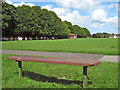
Playing fields, Hamilton Road, Taunton
Image: © Ken Grainger
Taken: 30 Jul 2009
0.22 miles
10
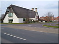
The "Master Thatcher", Taunton
It may be thatched but this is a modern pub, next to a Tesco Express and set amidst the extensive housing estates of south-east Taunton. Seen from the south across Lisieux (twin town) Way. 2:30 pm
Image: © Derek Harper
Taken: 11 Mar 2006
0.22 miles