IMAGES TAKEN NEAR TO
Bearley Road, MARTOCK, TA12 6PG
Introduction
This page details the photographs taken nearby to Bearley Road, TA12 6PG by members of the Geograph project.
The Geograph project started in 2005 with the aim of publishing, organising and preserving representative images for every square kilometre of Great Britain, Ireland and the Isle of Man.

There are currently over 7.5m images from over14,400 individuals and you can help contribute to the project by visiting https://www.geograph.org.uk
Image Map
Images are licensed for reuse under creativecommons.org/licenses/by-sa/2.0
Notes
- Clicking on the map will re-center to the selected point.
- The higher the marker number, the further away the image location is from the centre of the postcode.
Image Listing (21 Images Found)
Images are licensed for reuse under creativecommons.org/licenses/by-sa/2.0
Image
Details
Distance
2
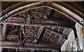
Martock, All Saints Church: The magnificent carved, quilted roof 3
Image: © Michael Garlick
Taken: 22 Apr 2017
0.13 miles
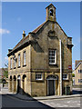
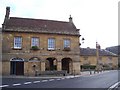
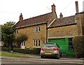
3
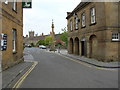
Martock
The village of Martock showing the Market House built in the 1750's, the White Hart hotel, Martock Pinnacle and All Saints Church in the background.
Image: © Liz Martin
Taken: 13 May 2005
0.13 miles
4
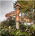
Old Direction Sign - Signpost by East Street, Martock
Pyramid finial - 2 arms; Somerset SCC pyramid by the UC road, in parish of Martock (South Somerset District), junction of East Street with Foldhill Lane, behind stone garden wall and hedge.
To be surveyed
Milestone Society National ID: SO_ST4619
Image: © Milestone Society
Taken: Unknown
0.16 miles
10
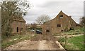
Madey Mill
"Probably one of 2 Domesday mills - this mill known as Madey mill since C14; in 1592 was coupled with a horse mill; it passed to the Manor in 1637, and was probably rebuilt soon after." http://www.imagesofengland.org.uk/details/default.aspx?id=423589 for further details. On the left is the C18 Madey Mill Farmhouse - see http://www.imagesofengland.org.uk/Details/Default.aspx?id=423588&mode=adv . Seen from footpath Y16/17A.
Image: © Derek Harper
Taken: 13 Mar 2009
0.23 miles