IMAGES TAKEN NEAR TO
Carpenters Terrace, Stapleton Road, MARTOCK, TA12 6HF
Introduction
This page details the photographs taken nearby to Carpenters Terrace, Stapleton Road, TA12 6HF by members of the Geograph project.
The Geograph project started in 2005 with the aim of publishing, organising and preserving representative images for every square kilometre of Great Britain, Ireland and the Isle of Man.

There are currently over 7.5m images from over14,400 individuals and you can help contribute to the project by visiting https://www.geograph.org.uk
Image Map
Images are licensed for reuse under creativecommons.org/licenses/by-sa/2.0
Notes
- Clicking on the map will re-center to the selected point.
- The higher the marker number, the further away the image location is from the centre of the postcode.
Image Listing (15 Images Found)
Images are licensed for reuse under creativecommons.org/licenses/by-sa/2.0
Image
Details
Distance
2
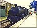
Martock railway station - the last day
Martock railway station on the last day of operation. A train for Yeovil arrives, hauled by a former Southern Railway 2-6-0 locomotive.
Image: © Richard Green
Taken: 13 Jun 1964
0.13 miles
3
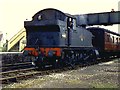
Yeovil train at Martock on the last day
Martock station on the last day of the Yeovil Town - Durston line. A train for Yeovil awaits departure.
Image: © Richard Green
Taken: 13 Jun 1964
0.13 miles
4
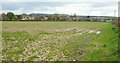
Edge of Martock
Looking right from the same gateway as Image], with housing north of the site of the former station. The field on the left is an orchard. In the distance is Ham Hill.
Image: © Derek Harper
Taken: 16 Apr 2016
0.13 miles
5
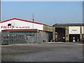
Retail sheds, Martock
On the site of Martock's railway station.
Image: © Richard Webb
Taken: 21 Apr 2011
0.16 miles
6
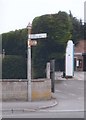
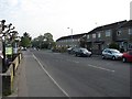
Old Direction Sign - Signpost by the B3165, Stapleton Road, Martock
Pyramid finial - 2 arms; Somerset SCC pyramid by the B3165, in parish of Martock (South Somerset District), opposite Coat Road junction with Stapleton Road.
Surveyed
Milestone Society National ID: SO_ST4620B
Image: © Milestone Society
Taken: Unknown
0.17 miles
7
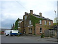
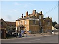
Martock
The former Railway Hotel, now a public house. Martock railway station and the Great Western Railway line from Langport to Yeovil once stood opposite the hotel.
Image: © Liz Martin
Taken: 31 May 2005
0.18 miles
8
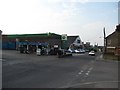
Garage, Stapleton Road
£1.46/l for diesel. April 2011.
Image: © Richard Webb
Taken: 21 Apr 2011
0.19 miles
9
The Railway
Public house undergoing renovation, it is situated opposite the site of Martock railway station.
Image: © Richard Webb
Taken: 21 Apr 2011
0.19 miles
10
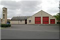
Martock fire station
Martock fire station, Coat Road, Martock, Somerset.
Image: © Kevin Hale
Taken: 10 Aug 2006
0.19 miles