IMAGES TAKEN NEAR TO
French Weir Avenue, TAUNTON, TA1 1AW
Introduction
This page details the photographs taken nearby to French Weir Avenue, TA1 1AW by members of the Geograph project.
The Geograph project started in 2005 with the aim of publishing, organising and preserving representative images for every square kilometre of Great Britain, Ireland and the Isle of Man.

There are currently over 7.5m images from over14,400 individuals and you can help contribute to the project by visiting https://www.geograph.org.uk
Image Map
Images are licensed for reuse under creativecommons.org/licenses/by-sa/2.0
Notes
- Clicking on the map will re-center to the selected point.
- The higher the marker number, the further away the image location is from the centre of the postcode.
Image Listing (78 Images Found)
Images are licensed for reuse under creativecommons.org/licenses/by-sa/2.0
Image
Details
Distance
1
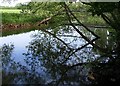
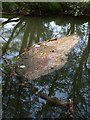
River Tone by French Weir Park
Trees reflected in a placid stretch of the river some 150 metres north of the weir. On the bend, a pipe can be seen crossing the river.
Image: © Derek Harper
Taken: 10 May 2008
0.02 miles
2
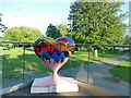
Follow Your Heart: Love Flows
This heart on the terrace of the cafe in French Weir Park was decorated by Keith Crocker. See Shared Description.
Image: © Stephen Craven
Taken: 15 Jul 2021
0.03 miles
3
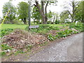
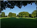
Taunton : Footpath
A footpath heads through French Weir Park.
Image: © Lewis Clarke
Taken: 18 Jan 2021
0.03 miles
4
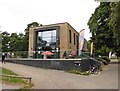
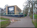
'Channel' watersports centre, Taunton
Image: © Roger Cornfoot
Taken: 18 Jul 2020
0.04 miles
5
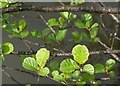
Alder by the Tone
Alder leaves on a tree overhanging the River Tone at the edge of French Weir Park, a little way upstream from the weir.
Image: © Derek Harper
Taken: 10 May 2008
0.04 miles
6
Channel to Channel (349)
Riverside is reached here.
Image: © Shazz
Taken: 26 Apr 2015
0.04 miles
7
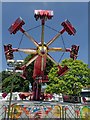
Funfair at French Weir
Shortly after the photographer took a ride and wished he hadn't.
Image: © Nick Chipchase
Taken: 28 May 2018
0.05 miles
8
The Two Counties Way
The Two Counties Way Long Distance Path largely follows the Grand Western Canal as it connects Taunton to the Mouth of the River Exe, some 56 miles (90km).
Image: © Neil Owen
Taken: 30 Oct 2014
0.06 miles
9
French Weir Park, Taunton
Named after the nearby weir on the river Tone.
Image: © Stephen Craven
Taken: 15 Jul 2021
0.06 miles
10
Mixed flotsam, River Tone
A rather unattractive collection of surface debris trapped by two fallen branches is graced by red petals, I think from a horse chestnut. Just above French Weir.
Image: © Derek Harper
Taken: 10 May 2008
0.06 miles