IMAGES TAKEN NEAR TO
Firepool Crescent, TAUNTON, TA1 1AT
Introduction
This page details the photographs taken nearby to Firepool Crescent, TA1 1AT by members of the Geograph project.
The Geograph project started in 2005 with the aim of publishing, organising and preserving representative images for every square kilometre of Great Britain, Ireland and the Isle of Man.

There are currently over 7.5m images from over14,400 individuals and you can help contribute to the project by visiting https://www.geograph.org.uk
Image Map
Images are licensed for reuse under creativecommons.org/licenses/by-sa/2.0
Notes
- Clicking on the map will re-center to the selected point.
- The higher the marker number, the further away the image location is from the centre of the postcode.
Image Listing (138 Images Found)
Images are licensed for reuse under creativecommons.org/licenses/by-sa/2.0
Image
Details
Distance
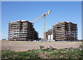
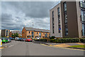
2
New housing at Obridge
This estate is close to the new Northern Distributor Road from Priory to Staplegrove.
Image: © Nick Chipchase
Taken: 1 Jun 2018
0.02 miles
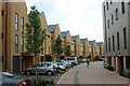
3
Taunton : Firepool Crescent
Looking along Firepool Crescent.
Image: © Lewis Clarke
Taken: 1 Aug 2020
0.03 miles
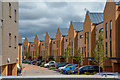
5
Taunton : Abbey Close
Looking along Abbey Close off Trenchard Way.
Image: © Lewis Clarke
Taken: 1 Aug 2020
0.04 miles

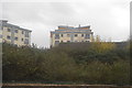
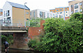
7

New housing near Firepool
In the foreground The Taunton and Bridgwater Canal.
Image: © Nick Chipchase
Taken: 1 Jun 2018
0.04 miles
8

Northern Inner Distributor Road
A bridge over the Bridgwater Canal and Tone on a new road. The road opening has been delayed as flooding delayed the construction of the bridge.
Image: © Richard Webb
Taken: 6 Apr 2015
0.06 miles
9
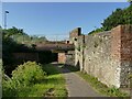
Winckworth Way bridge
The bridge carries Winckworth Way (which is pedestrianised south of this point) over the canal. There is a sewer pipe (helpfully named as such on old large-scale maps) that led to the town sewage works on the site of what is now the Priory Way industrial estate. The present sewage works is 5km further downriver at Image
Image: © Stephen Craven
Taken: 16 Jul 2021
0.06 miles
10
New housing at Obridge
An eclectic mix of buildings.
Image: © Nick Chipchase
Taken: 1 Jun 2018
0.06 miles