IMAGES TAKEN NEAR TO
South Hill, SOMERTON, TA11 7JQ
Introduction
This page details the photographs taken nearby to South Hill, TA11 7JQ by members of the Geograph project.
The Geograph project started in 2005 with the aim of publishing, organising and preserving representative images for every square kilometre of Great Britain, Ireland and the Isle of Man.

There are currently over 7.5m images from over14,400 individuals and you can help contribute to the project by visiting https://www.geograph.org.uk
Image Map (Loading...)


Getting Data...Please wait
Leaflet Map data © OpenStreetMap
Images are licensed for reuse under creativecommons.org/licenses/by-sa/2.0
Notes
- Clicking on the map will re-center to the selected point.
- The higher the marker number, the further away the image location is from the centre of the postcode.
Image Listing (6 Images Found)
Images are licensed for reuse under creativecommons.org/licenses/by-sa/2.0
Image
Details
Distance
1
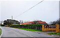
Houses at Southfield Farm
These houses are at South Hill on the B3165 Sutton Rd just south of Badger's Cross
Image: © Nigel Mykura
Taken: 7 Jan 2022
0.07 miles
2
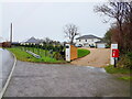
Portland House
Portland House is a large detached house located on a bend in the Sutton Rd, the B3165 just south of Somerton.
Image: © Nigel Mykura
Taken: 7 Jan 2022
0.17 miles
4
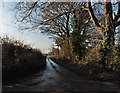
Windyridge Lane
A minor road serving residential properties and Windyridge Farm.
Image: © Richard Webb
Taken: 21 Apr 2011
0.19 miles
5
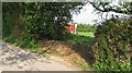
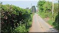
Sealed off gateway
More evidence of the fear of travellers. It appears that the 1990s are alive and well here with many gateways blocked, with good reason if it is still like the 1990s.
In East Lothian, this tactic is used but they just dig a way in.
Image: © Richard Webb
Taken: 21 Apr 2011
0.20 miles
6
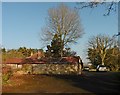
Stone outhouse on Harding's Hill
Appears to have been constructed without mortar.
Image: © Roger Cornfoot
Taken: 25 Jan 2017
0.23 miles