IMAGES TAKEN NEAR TO
Catcombe, SOMERTON, TA11 7JH
Introduction
This page details the photographs taken nearby to TA11 7JH by members of the Geograph project.
The Geograph project started in 2005 with the aim of publishing, organising and preserving representative images for every square kilometre of Great Britain, Ireland and the Isle of Man.

There are currently over 7.5m images from over14,400 individuals and you can help contribute to the project by visiting https://www.geograph.org.uk
Image Map (Loading...)


Getting Data...Please wait
Leaflet Map data © OpenStreetMap
Images are licensed for reuse under creativecommons.org/licenses/by-sa/2.0
Notes
- Clicking on the map will re-center to the selected point.
- The higher the marker number, the further away the image location is from the centre of the postcode.
Image Listing (4 Images Found)
Images are licensed for reuse under creativecommons.org/licenses/by-sa/2.0
Image
Details
Distance

2

Road drops down towards Somerton
Image: © Sarah Charlesworth
Taken: 16 Jun 2011
0.20 miles
3
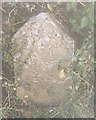
Old Milestone by the B3165, Sutton Road, south of Somerton
Stone post (plate lost) by the B3165, in parish of Somerton (South Somerset District), a mile South of Somerton, in hedge beside road, on East side of road. Martock iron plate, erected by the Martock & South Petherton turnpike trust in the 19th century.
Inscription once read:-
(Somerton 1)
(Long Sutton 2)
Somerset HER.
HER number: 19771 https://www.heritagegateway.org.uk/Gateway/Results_Single.aspx?uid=19771&resourceID=100
Milestone Society National ID: SO_SOWL01
Image: © JR Dowding
Taken: 2 Feb 2003
0.20 miles