IMAGES TAKEN NEAR TO
Babcary, SOMERTON, TA11 7EJ
Introduction
This page details the photographs taken nearby to TA11 7EJ by members of the Geograph project.
The Geograph project started in 2005 with the aim of publishing, organising and preserving representative images for every square kilometre of Great Britain, Ireland and the Isle of Man.

There are currently over 7.5m images from over14,400 individuals and you can help contribute to the project by visiting https://www.geograph.org.uk
Image Map (Loading...)


Getting Data...Please wait
Leaflet Map data © OpenStreetMap
Images are licensed for reuse under creativecommons.org/licenses/by-sa/2.0
Notes
- Clicking on the map will re-center to the selected point.
- The higher the marker number, the further away the image location is from the centre of the postcode.
Image Listing (7 Images Found)
Images are licensed for reuse under creativecommons.org/licenses/by-sa/2.0
Image
Details
Distance
1
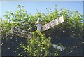
Old Direction Sign - Signpost near Sunny Hill Farm, Babcary parish
Pyramid finial - 3 arms; Somerset SCC pyramid by the UC road, in parish of Babcary (South Somerset District), Sunny Hill Farm, East of village.
Surveyed
Milestone Society National ID: SO_ST5728
Image: © Milestone Society
Taken: Unknown
0.08 miles
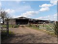
5
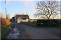
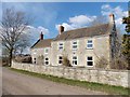
Cottages at West Farm
West Farm lies on the minor road from Babcary to South Barrow between Babcary and Foddington
Image: © Nigel Mykura
Taken: 26 Dec 2017
0.20 miles
6
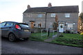
Cottages at West Farm
This pair of semi detached cottages is one of two pairs on the north eastern side of the lane running from Babcary to South barrow.
Image: © Nigel Mykura
Taken: 26 Dec 2017
0.20 miles