IMAGES TAKEN NEAR TO
Babcary, SOMERTON, TA11 7EE
Introduction
This page details the photographs taken nearby to TA11 7EE by members of the Geograph project.
The Geograph project started in 2005 with the aim of publishing, organising and preserving representative images for every square kilometre of Great Britain, Ireland and the Isle of Man.

There are currently over 7.5m images from over14,400 individuals and you can help contribute to the project by visiting https://www.geograph.org.uk
Image Map (Loading...)


Getting Data...Please wait
Leaflet Map data © OpenStreetMap
Images are licensed for reuse under creativecommons.org/licenses/by-sa/2.0
Notes
- Clicking on the map will re-center to the selected point.
- The higher the marker number, the further away the image location is from the centre of the postcode.
Image Listing (6 Images Found)
Images are licensed for reuse under creativecommons.org/licenses/by-sa/2.0
Image
Details
Distance
1
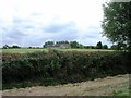
Bower's Farm
View from public road over hedge and field to Bower's Farm
Image: © Damon Knight
Taken: 1 Sep 2007
0.05 miles
4
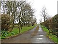
Little Steart House
View from public road east along lane to Little Steart House
Image: © Damon Knight
Taken: 1 Sep 2007
0.18 miles
5
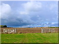
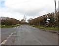
Fields at Woodlands Farm
This large double gateway giving entrance to a large arable field is presumably to allow easy access for large machinery such as combine harvesters. The field was once four smaller fields but the hedgerows have been removed.The field has been ploughed and seeded recently. The gateway also marks the start of a footpath.
Image: © Nigel Mykura
Taken: 18 Sep 2011
0.20 miles
6
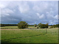
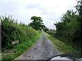
Fields at Steart Lane
View across the pasture fields towards the river Cary whose meandering line is marked by the bushes and trees.
Image: © Nigel Mykura
Taken: 18 Sep 2011
0.22 miles