IMAGES TAKEN NEAR TO
West Lydford, SOMERTON, TA11 7BT
Introduction
This page details the photographs taken nearby to TA11 7BT by members of the Geograph project.
The Geograph project started in 2005 with the aim of publishing, organising and preserving representative images for every square kilometre of Great Britain, Ireland and the Isle of Man.

There are currently over 7.5m images from over14,400 individuals and you can help contribute to the project by visiting https://www.geograph.org.uk
Image Map (Loading...)


Getting Data...Please wait
Leaflet Map data © OpenStreetMap
Images are licensed for reuse under creativecommons.org/licenses/by-sa/2.0
Notes
- Clicking on the map will re-center to the selected point.
- The higher the marker number, the further away the image location is from the centre of the postcode.
Image Listing (6 Images Found)
Images are licensed for reuse under creativecommons.org/licenses/by-sa/2.0
Image
Details
Distance
1
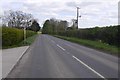
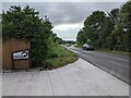
B3153, Keinton Mandeville
Heading towards the Fosse Way.
Image: © Richard Webb
Taken: 10 Apr 2017
0.06 miles
4
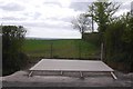
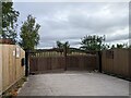
Construction, Keinton Mandeville
A new concrete base beside the B3153. Not exciting, but better here than some blurry stuff taken from a fast train which might just actually be within the square.
No idea what is being built, but it will be there now.
Image: © Richard Webb
Taken: 10 Apr 2017
0.09 miles