IMAGES TAKEN NEAR TO
Horse Mill Lane, SOMERTON, TA11 7BS
Introduction
This page details the photographs taken nearby to Horse Mill Lane, TA11 7BS by members of the Geograph project.
The Geograph project started in 2005 with the aim of publishing, organising and preserving representative images for every square kilometre of Great Britain, Ireland and the Isle of Man.

There are currently over 7.5m images from over14,400 individuals and you can help contribute to the project by visiting https://www.geograph.org.uk
Image Map (Loading...)


Getting Data...Please wait
Leaflet Map data © OpenStreetMap
Images are licensed for reuse under creativecommons.org/licenses/by-sa/2.0
Notes
- Clicking on the map will re-center to the selected point.
- The higher the marker number, the further away the image location is from the centre of the postcode.
Image Listing (21 Images Found)
Images are licensed for reuse under creativecommons.org/licenses/by-sa/2.0
Image
Details
Distance
2
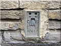
Ordnance Survey Flush Bracket 10817
This can be found on the wall of a former factory building in Horse Mill Lane.
For more detail see : http://www.bench-marks.org.uk/bm18804
Image: © Peter Wood
Taken: 31 Mar 2014
0.03 miles
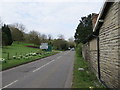
3
Junction of B3151 and B3153
Near to Somerton this junction often has a queue or two.
Image: © Steve Barnes
Taken: 24 Aug 2009
0.06 miles
4
Meadow land beside the River Cary
A sheen of Buttercups spread over toward the distant banks of the River Cary
Image: © Ant Basterfield
Taken: 16 May 2015
0.07 miles
6

River Cary
The river looking upstream from Cary Bridge on the B3151 just outside Somerton.
Image: © Derek Harper
Taken: 15 Oct 2008
0.12 miles
7
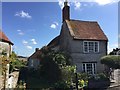
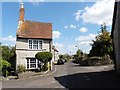
Cottage at end of New Street, Somerton
This old cottage stands like an exclamation mark at the end of the street.
Image: © elaine owen
Taken: 23 Aug 2019
0.15 miles
8
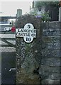
Old Milestone by New Street, Somerton
Metal plate attached to stone post by the UC road, in parish of SOMERTON (SOUTH SOMERSET District), New Street, front boundary wall of Hillhead Cottage, built into wall beside garden gate post, on South side of road. LSCC iron plate, erected by the Langport, Somerton & Castle Cary turnpike trust in the 19th century.
Inscription reads:-
5
LANGPOR(T)
CASTLE CA(RY)
10
Grade II listed.
List Entry Number: 1177545 https://historicengland.org.uk/listing/the-list/list-entry/1177545
Milestone Society National ID: SO_LPCC05
Image: © Mike Faherty
Taken: 27 Jan 2008
0.15 miles
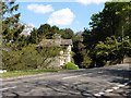
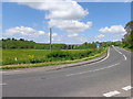
10
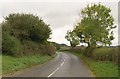
B3153 near Cary Bridge
The B3153 road leaves the junction with the B3151, heading towards Kingweston.
Image: © Derek Harper
Taken: 15 Oct 2008
0.16 miles