IMAGES TAKEN NEAR TO
Perry Hill Road, SOMERTON, TA11 6SR
Introduction
This page details the photographs taken nearby to Perry Hill Road, TA11 6SR by members of the Geograph project.
The Geograph project started in 2005 with the aim of publishing, organising and preserving representative images for every square kilometre of Great Britain, Ireland and the Isle of Man.

There are currently over 7.5m images from over14,400 individuals and you can help contribute to the project by visiting https://www.geograph.org.uk
Image Map (Loading...)


Getting Data...Please wait
Leaflet Map data © OpenStreetMap
Images are licensed for reuse under creativecommons.org/licenses/by-sa/2.0
Notes
- Clicking on the map will re-center to the selected point.
- The higher the marker number, the further away the image location is from the centre of the postcode.
Image Listing (6 Images Found)
Images are licensed for reuse under creativecommons.org/licenses/by-sa/2.0
Image
Details
Distance
1
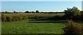
Farmland near Somerton
The Mill Stream flows past the other side of this little meadow, with maize beyond. Amongst trees in the background is Perry Hill Farm, in Image
Image: © Derek Harper
Taken: 30 Sep 2015
0.17 miles
4
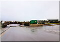
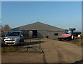
Jubilee Park Industrial Estate
This small industrial estate close to Badger's Cross was starting to flood at the lowest point due to recent heavy rain.
Image: © Nigel Mykura
Taken: 7 Jan 2022
0.21 miles
5
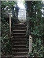
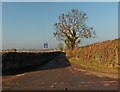
Steps to Station Path
The path closely follows the tracks south-west out of the town and drops onto the road at these steps. The bright white wooden gate lends a style reminiscent of the railways.
Image: © Neil Owen
Taken: 28 Jul 2022
0.23 miles