IMAGES TAKEN NEAR TO
Camden Orchard, SOMERTON, TA11 6RL
Introduction
This page details the photographs taken nearby to Camden Orchard, TA11 6RL by members of the Geograph project.
The Geograph project started in 2005 with the aim of publishing, organising and preserving representative images for every square kilometre of Great Britain, Ireland and the Isle of Man.

There are currently over 7.5m images from over14,400 individuals and you can help contribute to the project by visiting https://www.geograph.org.uk
Image Map (Loading...)


Getting Data...Please wait
Leaflet Map data © OpenStreetMap
Images are licensed for reuse under creativecommons.org/licenses/by-sa/2.0
Notes
- Clicking on the map will re-center to the selected point.
- The higher the marker number, the further away the image location is from the centre of the postcode.
Image Listing (52 Images Found)
Images are licensed for reuse under creativecommons.org/licenses/by-sa/2.0
Image
Details
Distance
1
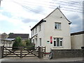
The Old Presbytery
One of a number of religious buildings in this part of Somerton; there used to be a Mission Hall and then a Salvation Army hall just opposite.
Image: © Neil Owen
Taken: 28 Jul 2022
0.06 miles
2
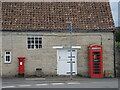
View from Pound Pool
Poundwell Barn has some communnications company, as well as a bin. See CCCC for a look at the letter box; the phone booth is empty of equipment, though.
Image: © Neil Owen
Taken: 28 Jul 2022
0.06 miles
3
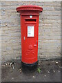
Poundwell postbox
A Georgian version, marked as TA11 430D.
Image: © Neil Owen
Taken: 28 Jul 2022
0.07 miles
4
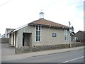
St Dunstan's Church, Somerton
A relatively modern Catholic church in West End.
Image: © Neil Owen
Taken: 28 Jul 2022
0.07 miles
5
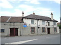
The Royal Oak, Somerton
The Royal Oak was refurbished last year and now has a new menu on offer.
Image: © Neil Owen
Taken: 28 Jul 2022
0.08 miles
6
St Dunstan's Catholic Church, Somerton
Image: © Roger Cornfoot
Taken: 4 Jan 2017
0.08 miles
7

Benchmark on Somerton's old school
Located on Langport Road in the middle of town, the nineteenth century benchmark lies on the old school rooms and now very close to the modern lavement level. See Image] for a wider view and https://www.bench-marks.org.uk/bm176208 for the entry in the Benchmark Database.
Image: © Neil Owen
Taken: 28 Jul 2022
0.09 miles
8

The old school house, Somerton
Located in Behind Berry, the old school buildings are a typical example of local work. The land-owning Pinney family built several buildings in the town, with Ham Stone the usual choice for them. The school was built in the mid-nineteenth century with later additions and extensions; it was subseqenetly closed as a new school was founded elsewhere. Grade II listed.
A benchmark of similar age lies on the lower course close to the modern pavement level - see Image
Image: © Neil Owen
Taken: 28 Jul 2022
0.09 miles
9
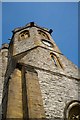
St Michael and All Angels Church, Somerton
Image: © Roger May
Taken: 21 Mar 2012
0.11 miles
10
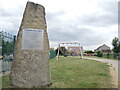
Etsome Terrace memorial stone
In the twentieth century this site in Somerton was home to the Cow and Gate milk factory. On 29th September, 1942, a German air raid attacked Bristol but one lone aircraft struck here. Flying at low level it dropped four time-fused bombs which landed on the factory; the fuses were short and the blasts killed nine employees. Their names are dedicated on this stone.
Image: © Neil Owen
Taken: 28 Jul 2022
0.11 miles