IMAGES TAKEN NEAR TO
St. Cleers Road, SOMERTON, TA11 6QS
Introduction
This page details the photographs taken nearby to St. Cleers Road, TA11 6QS by members of the Geograph project.
The Geograph project started in 2005 with the aim of publishing, organising and preserving representative images for every square kilometre of Great Britain, Ireland and the Isle of Man.

There are currently over 7.5m images from over14,400 individuals and you can help contribute to the project by visiting https://www.geograph.org.uk
Image Map (Loading...)


Getting Data...Please wait
Leaflet Map data © OpenStreetMap
Images are licensed for reuse under creativecommons.org/licenses/by-sa/2.0
Notes
- Clicking on the map will re-center to the selected point.
- The higher the marker number, the further away the image location is from the centre of the postcode.
Image Listing (22 Images Found)
Images are licensed for reuse under creativecommons.org/licenses/by-sa/2.0
Image
Details
Distance
1
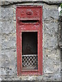
Empty post box on St Cleer's
An Edward VII postbox (a W.T. Allen product) has lost its lid. See Image] for a location view.
Image: © Neil Owen
Taken: 28 Jul 2022
0.01 miles
2
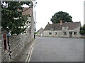
To St Cleers Cottage
The road junction features a small wall-mounted post box - see Image] for a better look.
Image: © Neil Owen
Taken: 28 Jul 2022
0.01 miles
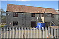
3
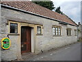
St Cleer's Chapel
The community is an independent Evangelical church, and the space was extended in 1993.
Image: © Neil Owen
Taken: 28 Jul 2022
0.05 miles
4
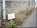
Weedkiller alert
A sign gives some important information, particularly to dogs perhaps.
Image: © Neil Owen
Taken: 28 Jul 2022
0.08 miles
7

Drain under Polham Lane
Somerton lies fairly low in the Somerset countryside and there are a number of drains traversing the town. The drain runs from what was called Water Lane (but is now St Cleer's Way) and down to Mill Stream.
Image: © Neil Owen
Taken: 28 Jul 2022
0.10 miles
8
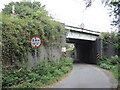
Polham Lane bridge
The road winds around the tracks above; see Image] for a look at the curved sections of construction under the lines.
Image: © Neil Owen
Taken: 28 Jul 2022
0.11 miles
9
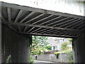
A twist in the tracks
Polham Lane bridge has a road passing under which turns as well. Given that, the bridge has an unusual design of steel supports. See Image] for a wider view.
Image: © Neil Owen
Taken: 28 Jul 2022
0.11 miles
10
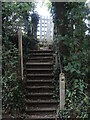
Steps to Station Path
The path closely follows the tracks south-west out of the town and drops onto the road at these steps. The bright white wooden gate lends a style reminiscent of the railways.
Image: © Neil Owen
Taken: 28 Jul 2022
0.11 miles