IMAGES TAKEN NEAR TO
The Triangle, SOMERTON, TA11 6NE
Introduction
This page details the photographs taken nearby to The Triangle, TA11 6NE by members of the Geograph project.
The Geograph project started in 2005 with the aim of publishing, organising and preserving representative images for every square kilometre of Great Britain, Ireland and the Isle of Man.

There are currently over 7.5m images from over14,400 individuals and you can help contribute to the project by visiting https://www.geograph.org.uk
Image Map (Loading...)


Getting Data...Please wait
Leaflet Map data © OpenStreetMap
Images are licensed for reuse under creativecommons.org/licenses/by-sa/2.0
Notes
- Clicking on the map will re-center to the selected point.
- The higher the marker number, the further away the image location is from the centre of the postcode.
Image Listing (184 Images Found)
Images are licensed for reuse under creativecommons.org/licenses/by-sa/2.0
Image
Details
Distance
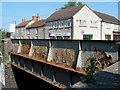
1
Signpost at Pye Corner
The triangular spot at the road junction is where the Langport and Sutton Roads meet. A Somerset signpost also marks Cycle Route 30.
Image: © Neil Owen
Taken: 28 Jul 2022
0.02 miles
2
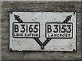
Old Direction Sign - Signpost by the B3165, Pye Corner, Somerton
Pyramid finial - 3 arms, 1 missing; Somerset SCC pyramid by the B3165, in parish of Somerton (South Somerset District), Y-junction of Sutton Road, Langport Road and West Street.
Surveyed
Milestone Society National ID: SO_ST4828
Image: © Milestone Society
Taken: Unknown
0.02 miles
3
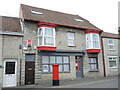
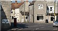
The old post office
Until fairly recently this red house was Somerton's Post Office; when the new shopping centre was created the office moved there.
Image: © Neil Owen
Taken: 28 Jul 2022
0.03 miles
4
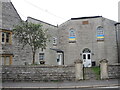
The Zion Chapel
Founded as a Bible Christian chapel the building has closed as a place of worship and is now a private residence - the occupants clearly support Ukraine.
Image: © Neil Owen
Taken: 28 Jul 2022
0.04 miles
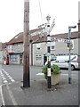
5
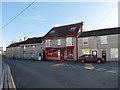
Post office at The Triangle, Somerton
Image: © Roger Cornfoot
Taken: 4 Jan 2017
0.04 miles
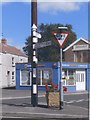
6
Old signs, West Street, Somerton
Pre-Worboys signs are popular on the site right now, here is one in Somerton along with a Somerset County Council finger posts which seem to have survived in good numbers, even in town centres.
Image: © Richard Webb
Taken: 21 Apr 2011
0.04 miles
7
Direction Sign ? Signpost
Plate fixed to a house wall at ground floor level on the south side of the B3165 The Triangle in Somerton parish. See also https://www.geograph.org.uk/photo/2480734.
Milestone Society National ID: SO_ST4828C
Image: © J Mullinger
Taken: 20 Jul 2019
0.04 miles
8

The Head
Cast head jutting from a small town cottage, above a lintel marked 1832.
Image: © sean mulligan
Taken: 26 Aug 2008
0.06 miles
9
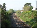
Site of Somerton station
Amazing - a railway runs through a town centre and there is no station. Can only be a matter of time before one is opened given the expansion of the town in recent years, and that is before you take into account booming Street, 8km to the north.
Image: © Richard Webb
Taken: 21 Apr 2011
0.06 miles