IMAGES TAKEN NEAR TO
Etsome Close, SOMERTON, TA11 6LR
Introduction
This page details the photographs taken nearby to Etsome Close, TA11 6LR by members of the Geograph project.
The Geograph project started in 2005 with the aim of publishing, organising and preserving representative images for every square kilometre of Great Britain, Ireland and the Isle of Man.

There are currently over 7.5m images from over14,400 individuals and you can help contribute to the project by visiting https://www.geograph.org.uk
Image Map (Loading...)


Getting Data...Please wait
Leaflet Map data © OpenStreetMap
Images are licensed for reuse under creativecommons.org/licenses/by-sa/2.0
Notes
- Clicking on the map will re-center to the selected point.
- The higher the marker number, the further away the image location is from the centre of the postcode.
Image Listing (31 Images Found)
Images are licensed for reuse under creativecommons.org/licenses/by-sa/2.0
Image
Details
Distance
1
School's out for good
Somerton Infant School closed in 2014. The King Ina school had two sites at either end of the town so plans were made to create a new school facility in the Northfield development.
Image: © Neil Owen
Taken: 28 Jul 2022
0.05 miles
2
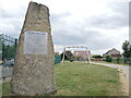
Etsome Terrace memorial stone
In the twentieth century this site in Somerton was home to the Cow and Gate milk factory. On 29th September, 1942, a German air raid attacked Bristol but one lone aircraft struck here. Flying at low level it dropped four time-fused bombs which landed on the factory; the fuses were short and the blasts killed nine employees. Their names are dedicated on this stone.
Image: © Neil Owen
Taken: 28 Jul 2022
0.06 miles
3
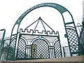
Etsome Memorial Garden
This small play area on Etsome Terrace stands between the fire station and the school buildings. However, from 1927 this area was the milk factory, which was bombed in an air raid in 1942. The factory carried on until the 1960s until the firm went elsewhere, leaving a landmark chimney for demolition.
As a tribute to the people killed in the war, this garden and entrance gate was built.
Image: © Neil Owen
Taken: 28 Jul 2022
0.07 miles
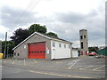
4
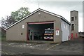
Somerton fire station
Somerton fire station, Pound Pool, Somerton, Somerset, on a clearer day than when Image was taken. The station's Volvo FL6 water tender ladder with Saxon bodywork can be seen in the appliance bay.
Image: © Kevin Hale
Taken: 30 Apr 2010
0.07 miles
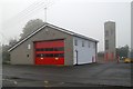
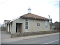
5
Somerton fire station
The station was built around 1967 after Cow and Gate sold off the land containing the former milk factory.
Image: © Neil Owen
Taken: 28 Jul 2022
0.08 miles
6
Somerton fire station
Somerton fire station, Pound Pool, Somerton, Somerset, on a foggy November day.
Image: © Kevin Hale
Taken: 7 Nov 2006
0.08 miles
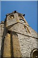
7
St Dunstan's Catholic Church, Somerton
Image: © Roger Cornfoot
Taken: 4 Jan 2017
0.10 miles
8
St Michael and All Angels Church, Somerton
Image: © Roger May
Taken: 21 Mar 2012
0.10 miles
9
St Dunstan's Church, Somerton
A relatively modern Catholic church in West End.
Image: © Neil Owen
Taken: 28 Jul 2022
0.11 miles
10
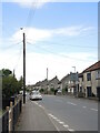
Above Behind Berry
The old part of Somerton with an odd name, Behind Berry, also holds an odd sight: above the telegraph pole is an artificial bird, attached to the top. See Image] for a better look at it.
Image: © Neil Owen
Taken: 28 Jul 2022
0.11 miles