IMAGES TAKEN NEAR TO
Laburnum Drive, SOMERTON, TA11 6LH
Introduction
This page details the photographs taken nearby to Laburnum Drive, TA11 6LH by members of the Geograph project.
The Geograph project started in 2005 with the aim of publishing, organising and preserving representative images for every square kilometre of Great Britain, Ireland and the Isle of Man.

There are currently over 7.5m images from over14,400 individuals and you can help contribute to the project by visiting https://www.geograph.org.uk
Image Map (Loading...)


Getting Data...Please wait
Leaflet Map data © OpenStreetMap
Images are licensed for reuse under creativecommons.org/licenses/by-sa/2.0
Notes
- Clicking on the map will re-center to the selected point.
- The higher the marker number, the further away the image location is from the centre of the postcode.
Image Listing (20 Images Found)
Images are licensed for reuse under creativecommons.org/licenses/by-sa/2.0
Image
Details
Distance
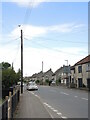
1

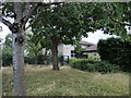
Looking west along Etsome Road, on the edge of Somerton
Image: © Rob Purvis
Taken: 21 Jul 2024
0.14 miles
2
School's out for good
Somerton Infant School closed in 2014. The King Ina school had two sites at either end of the town so plans were made to create a new school facility in the Northfield development.
Image: © Neil Owen
Taken: 28 Jul 2022
0.16 miles
3
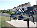
Memorial bench on Cedar Grove
This part of Somerton lies to the north of its centre and appears to be part of a post-WWII development. The road faces out onto open farmland but now has a bench dedicated to the memory of those involved in the war. Such benches are appearing in the twenty-first century.
Image: © Neil Owen
Taken: 28 Jul 2022
0.16 miles

5
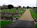
Somerton Cemetery
Somerton cemetery is located in the extreme north eastern corner of the grid square. It is just north of the B3153 and just west of the railway cutting containing the Taunton to Westbury line.
Image: © Nigel Mykura
Taken: 11 Nov 2009
0.20 miles
6
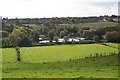
Somerton Fishing Ponds
The fishing ponds viewed from Littleton Hill.
Image: © Andy Pearce
Taken: 9 Oct 2008
0.21 miles
7
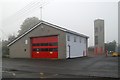
Somerton fire station
Somerton fire station, Pound Pool, Somerton, Somerset, on a foggy November day.
Image: © Kevin Hale
Taken: 7 Nov 2006
0.21 miles
8
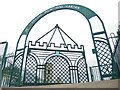
Etsome Memorial Garden
This small play area on Etsome Terrace stands between the fire station and the school buildings. However, from 1927 this area was the milk factory, which was bombed in an air raid in 1942. The factory carried on until the 1960s until the firm went elsewhere, leaving a landmark chimney for demolition.
As a tribute to the people killed in the war, this garden and entrance gate was built.
Image: © Neil Owen
Taken: 28 Jul 2022
0.21 miles
9
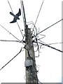
A stuffed bird on top of the pole
This telegraph pole in downtown Somerton has an artificial bird attached to the top, presumably to deter real birds from causing problems. See Image] for a location view.
Image: © Neil Owen
Taken: 28 Jul 2022
0.21 miles
10
Above Behind Berry
The old part of Somerton with an odd name, Behind Berry, also holds an odd sight: above the telegraph pole is an artificial bird, attached to the top. See Image] for a better look at it.
Image: © Neil Owen
Taken: 28 Jul 2022
0.21 miles