IMAGES TAKEN NEAR TO
Keinton Mandeville, SOMERTON, TA11 6EW
Introduction
This page details the photographs taken nearby to TA11 6EW by members of the Geograph project.
The Geograph project started in 2005 with the aim of publishing, organising and preserving representative images for every square kilometre of Great Britain, Ireland and the Isle of Man.

There are currently over 7.5m images from over14,400 individuals and you can help contribute to the project by visiting https://www.geograph.org.uk
Image Map (Loading...)


Getting Data...Please wait
Leaflet Map data © OpenStreetMap
Images are licensed for reuse under creativecommons.org/licenses/by-sa/2.0
Notes
- Clicking on the map will re-center to the selected point.
- The higher the marker number, the further away the image location is from the centre of the postcode.
Image Listing (14 Images Found)
Images are licensed for reuse under creativecommons.org/licenses/by-sa/2.0
Image
Details
Distance
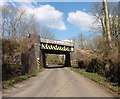
4
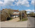
Railway Bridge across Common Lane
Photograph taken from byway by Southmead Farm facing north
Image: © Damon Knight
Taken: 1 Sep 2007
0.14 miles
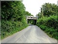
5
Railway Bridge, Common Lane
This shows where the bridge carrying the Somerton to Bruton Railway line crosses the minor road from Keinton Mandeville south to the A37
Image: © Nigel Mykura
Taken: 18 Sep 2011
0.14 miles
6
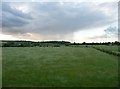
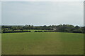
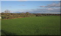
South Somerset : Grassy Field & Countryside
Image: © Lewis Clarke
Taken: 7 Jun 2009
0.16 miles
8
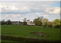
Farmland near Keinton Mandeville
A view across low-lying land around the River Cary, taken from a train on the main line from Castle Cary to Taunton. On the left is a corner of a barn at Southmead Farm. Hard to discern right in the centre is Thistledown Farm, in Image
Image: © Derek Harper
Taken: 19 Mar 2012
0.18 miles