IMAGES TAKEN NEAR TO
Silver Street, SOMERTON, TA11 6DD
Introduction
This page details the photographs taken nearby to Silver Street, TA11 6DD by members of the Geograph project.
The Geograph project started in 2005 with the aim of publishing, organising and preserving representative images for every square kilometre of Great Britain, Ireland and the Isle of Man.

There are currently over 7.5m images from over14,400 individuals and you can help contribute to the project by visiting https://www.geograph.org.uk
Image Map (Loading...)


Getting Data...Please wait
Leaflet Map data © OpenStreetMap
Images are licensed for reuse under creativecommons.org/licenses/by-sa/2.0
Notes
- Clicking on the map will re-center to the selected point.
- The higher the marker number, the further away the image location is from the centre of the postcode.
Image Listing (3 Images Found)
Images are licensed for reuse under creativecommons.org/licenses/by-sa/2.0
Image
Details
Distance
1
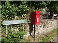
Silver Street
The road leads north to the hamlet of that name; from the postbox south is Park Lane. A rusty old milk church stands outside Manor Farm.
Image: © Neil Owen
Taken: 12 Jul 2020
0.23 miles