IMAGES TAKEN NEAR TO
Main Street, SOMERTON, TA11 6BZ
Introduction
This page details the photographs taken nearby to Main Street, TA11 6BZ by members of the Geograph project.
The Geograph project started in 2005 with the aim of publishing, organising and preserving representative images for every square kilometre of Great Britain, Ireland and the Isle of Man.

There are currently over 7.5m images from over14,400 individuals and you can help contribute to the project by visiting https://www.geograph.org.uk
Image Map (Loading...)


Getting Data...Please wait
Leaflet Map data © OpenStreetMap
Images are licensed for reuse under creativecommons.org/licenses/by-sa/2.0
Notes
- Clicking on the map will re-center to the selected point.
- The higher the marker number, the further away the image location is from the centre of the postcode.
Image Listing (39 Images Found)
Images are licensed for reuse under creativecommons.org/licenses/by-sa/2.0
Image
Details
Distance
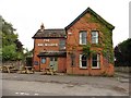
1
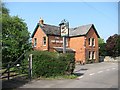
Pub of the year 2010
The Barton Inn was voted the Barton St David pub of the year 2010, according to their website. The upside down lettering is deliberate.
Image: © Richard Webb
Taken: 21 Apr 2011
0.01 miles
2
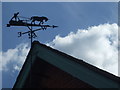
A rural weathervane on the pub
The Barton Inn now features a rather splendid weathervane.
Image: © Neil Owen
Taken: 12 Jul 2020
0.02 miles
4
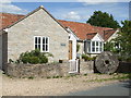
A mixed implication
A house on Barton's Main Street has a large grinding wheel outside, but its name is The Smithy. Perhaps there was a change of uses in its history, despite it not being more than a few decades old. Perhaps it is simply a nice name chosen by the owners.
Image: © Neil Owen
Taken: 12 Jul 2020
0.06 miles
6
Looking south down Main Street, Barton St. David
Taken opposite 'Avalon' the house where I grew up, looking south down Main Street alongside Stocks Farm.
Image: © Tim Cook
Taken: 14 Jul 2005
0.07 miles
7
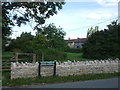
Barton St David Stocks Green
A small plot of land at the crossroads of Main Street, High Lane, Church Street and Mill Road is now given over to a community green space.
Image: © Neil Owen
Taken: 12 Jul 2020
0.09 miles
8
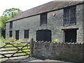
A large barn in Main Street
Some lovely features of an earlier way of farming.
Image: © Neil Owen
Taken: 12 Jul 2020
0.09 miles
9
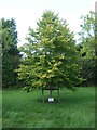
A lime tree for a fallen soldier
This tree was planted in memory of a soldier who fought in Helmand Province but killed in 2012.
Image: © Neil Owen
Taken: 12 Jul 2020
0.09 miles
10
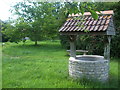
Stocks Green well
What appears as a typical water well is not actually so. The village bought this central plot of land in 1999 to landscape as a public green space, and the well is a decorative feature - it's made of a modern concrete water pipe section!
Image: © Neil Owen
Taken: 12 Jul 2020
0.09 miles