IMAGES TAKEN NEAR TO
Church Street, SOMERTON, TA11 6BX
Introduction
This page details the photographs taken nearby to Church Street, TA11 6BX by members of the Geograph project.
The Geograph project started in 2005 with the aim of publishing, organising and preserving representative images for every square kilometre of Great Britain, Ireland and the Isle of Man.

There are currently over 7.5m images from over14,400 individuals and you can help contribute to the project by visiting https://www.geograph.org.uk
Image Map (Loading...)


Getting Data...Please wait
Leaflet Map data © OpenStreetMap
Images are licensed for reuse under creativecommons.org/licenses/by-sa/2.0
Notes
- Clicking on the map will re-center to the selected point.
- The higher the marker number, the further away the image location is from the centre of the postcode.
Image Listing (53 Images Found)
Images are licensed for reuse under creativecommons.org/licenses/by-sa/2.0
Image
Details
Distance
1
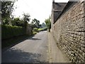
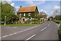
Looking south down Main Street, Barton St. David
Taken opposite 'Avalon' the house where I grew up, looking south down Main Street alongside Stocks Farm.
Image: © Tim Cook
Taken: 14 Jul 2005
0.02 miles
2
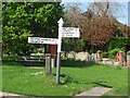
Fingerpost, Barton St David
It was a joy to see that the fingerposts had survived and were mostly freshly painted. I cannot remember ever seeing this rather effective use of red initials before. At least they have not taken a lead from the pub and turned the words upside down.
It is very noticeable how close villages are to each other here.
Image: © Richard Webb
Taken: 21 Apr 2011
0.03 miles
3
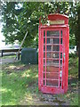
Red on the green
Barton St David is served by a traditional telephone box, situated on a small patch of grass at the crossroads. In older times the box was on the south side of the road but, following a change in the road layout, is now on a green island. The village still has some issues with modern communications and is hoping new broadband will arrive.
Image: © Neil Owen
Taken: 12 Jul 2020
0.03 miles
4
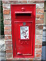
A Georgian post box in Barton St David
Repositioned outside what was the old Post Office.
Image: © Neil Owen
Taken: 12 Jul 2020
0.03 miles
5
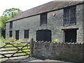
A large barn in Main Street
Some lovely features of an earlier way of farming.
Image: © Neil Owen
Taken: 12 Jul 2020
0.03 miles
6
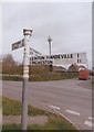
Old Direction Sign - Signpost by Main Street, Barton St David
Pyramid finial - 3 arms; Somerset SCC pyramid by the UC road, in parish of Barton St David (South Somerset District), Main Street, junction with High Lane and road to Plot Gate.
Surveyed
Milestone Society National ID: SO_ST5431A
Image: © Milestone Society
Taken: Unknown
0.03 miles
7
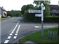
It's a local thing, red initials
The signpost at the crossroads in Barton St David features red initials, quite common round these parts.
Image: © Neil Owen
Taken: 12 Jul 2020
0.03 miles
8
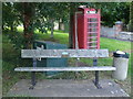
Coronation seat
In the centre of Barton St David is a commemorative bench seat, marking the Queen's coronation of June 2nd, 1953.
Image: © Neil Owen
Taken: 12 Jul 2020
0.03 miles
9
Coronation Seat Barton St David
This is Barton St David at the junction of High Lane, Church St, and Mill Lane. The seat was placed there to commemorate the coronation in 1953
Image: © Glyn Baker
Taken: 7 May 2006
0.04 miles
10
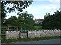
Barton St David Stocks Green
A small plot of land at the crossroads of Main Street, High Lane, Church Street and Mill Road is now given over to a community green space.
Image: © Neil Owen
Taken: 12 Jul 2020
0.04 miles