IMAGES TAKEN NEAR TO
Barton Road, SOMERTON, TA11 6BL
Introduction
This page details the photographs taken nearby to Barton Road, TA11 6BL by members of the Geograph project.
The Geograph project started in 2005 with the aim of publishing, organising and preserving representative images for every square kilometre of Great Britain, Ireland and the Isle of Man.

There are currently over 7.5m images from over14,400 individuals and you can help contribute to the project by visiting https://www.geograph.org.uk
Image Map
Images are licensed for reuse under creativecommons.org/licenses/by-sa/2.0
Notes
- Clicking on the map will re-center to the selected point.
- The higher the marker number, the further away the image location is from the centre of the postcode.
Image Listing (29 Images Found)
Images are licensed for reuse under creativecommons.org/licenses/by-sa/2.0
Image
Details
Distance
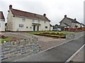
3
You can't see it through by car
A junction off Peacocks Hill is a road that shortly turns into a bridleway.
Image: © Neil Owen
Taken: 12 Jul 2020
0.10 miles
6
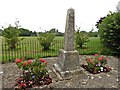
War Memorial, Barton St David
Looking a little unsteady on its foundations.
Image: © Roger Cornfoot
Taken: 19 Jul 2017
0.15 miles
7
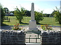
Barton St David war memorial
A little Garden of Remembrance situated at the corner of High Lane and Broadclose Way is the location for the monument. The obelisk records thirty-three men of Barton St David who went to war and the three who lost their lives doing so. The stone was in need of a little care and was cleaned and repaired in October, 2018.
Image: © Neil Owen
Taken: 12 Jul 2020
0.15 miles
8

Barton St David and Glastonbury Tor
The houses at Barton St David form the foreground, with the distinctive profile of the Tor Image behind. The white houses clinging to the side of the Tor are along the A361. The main town of Glastonbury is built around St John's Church, whose tower can be seen sticking up to the left of the Tor; behind it are the Mendip Hills.
Image: © Edwin Graham
Taken: 26 Jan 2008
0.15 miles
9
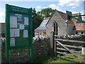
Parish notice board and village hall
Located right next to the recreation ground.
Image: © Neil Owen
Taken: 12 Jul 2020
0.16 miles
10
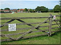
No place for dogs
It's a shame that dogs aren't allowed onto the recreation grounds for health reasons as that's why people go there. Sorry Fido, you'll have to exercise elsewhere.
Image: © Neil Owen
Taken: 12 Jul 2020
0.16 miles