IMAGES TAKEN NEAR TO
Russet Road, SOMERTON, TA11 6AU
Introduction
This page details the photographs taken nearby to Russet Road, TA11 6AU by members of the Geograph project.
The Geograph project started in 2005 with the aim of publishing, organising and preserving representative images for every square kilometre of Great Britain, Ireland and the Isle of Man.

There are currently over 7.5m images from over14,400 individuals and you can help contribute to the project by visiting https://www.geograph.org.uk
Image Map (Loading...)


Getting Data...Please wait
Leaflet Map data © OpenStreetMap
Images are licensed for reuse under creativecommons.org/licenses/by-sa/2.0
Notes
- Clicking on the map will re-center to the selected point.
- The higher the marker number, the further away the image location is from the centre of the postcode.
Image Listing (25 Images Found)
Images are licensed for reuse under creativecommons.org/licenses/by-sa/2.0
Image
Details
Distance
1

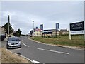
Housing development at Northfield Farm
Image: © Roger Cornfoot
Taken: 4 Jan 2017
0.05 miles
2
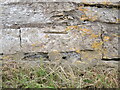
Benchmark on Bancombe Road
A nineteenth century benchmark, as listed in the Benchmark Database: https://www.bench-marks.org.uk/bm176207 , on an old building in Somerton. In the past the road would have been a more important and busy one, but today has been realigned to be more pedestrian friendly. See Image] for a wider view.
Image: © Neil Owen
Taken: 28 Jul 2022
0.05 miles
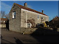
3
Buildings on Bancombe Road
Part of older Somerton near the main roads: there is a benchmark on the main building - see Image
Image: © Neil Owen
Taken: 28 Jul 2022
0.05 miles
4
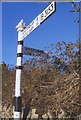
Old Direction Sign - Signpost by the B3153, Langport Road, Somerton
Pyramid finial - 2 arms; Somerset SCC pyramid by the UC road, in parish of Somerton (South Somerset District), Bancombe Road junction with Langport Road.
Surveyed
Milestone Society National ID: SO_ST4828B.
Image: © Milestone Society
Taken: Unknown
0.07 miles
5
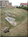
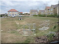
Leaving the balancing pond
The new houses built at the outskirts of Somerton have to cope with the potential of excessive rainfall causing flooding. A balancing pond has been created between the road and homes (see Image]) and the output will flow into the drainage ditch here.
Image: © Neil Owen
Taken: 28 Jul 2022
0.07 miles
6
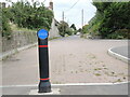
Cyclists dismount
The end of the new road network at Langport Road has a few extra bits of furniture.
Image: © Neil Owen
Taken: 28 Jul 2022
0.07 miles
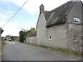
7
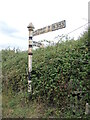
Signpost on Langport Road
A little weather-worn but still showing the old route on the old Northfield Farm area.
Image: © Neil Owen
Taken: 28 Jul 2022
0.08 miles
8
Drainage on Bancombe Road
The new estate has sprung up and has a small balancing pond to cope with any severe rainfall.
Image: © Neil Owen
Taken: 28 Jul 2022
0.08 miles