IMAGES TAKEN NEAR TO
Robins Way, TA11 6AR
Introduction
This page details the photographs taken nearby to Robins Way, TA11 6AR by members of the Geograph project.
The Geograph project started in 2005 with the aim of publishing, organising and preserving representative images for every square kilometre of Great Britain, Ireland and the Isle of Man.

There are currently over 7.5m images from over14,400 individuals and you can help contribute to the project by visiting https://www.geograph.org.uk
Image Map (Loading...)


Getting Data...Please wait
Leaflet Map data © OpenStreetMap
Images are licensed for reuse under creativecommons.org/licenses/by-sa/2.0
Notes
- Clicking on the map will re-center to the selected point.
- The higher the marker number, the further away the image location is from the centre of the postcode.
Image Listing (6 Images Found)
Images are licensed for reuse under creativecommons.org/licenses/by-sa/2.0
Image
Details
Distance
1
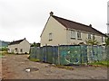
Unoccupied houses, Redlands
This new 'brown-field' development appears to have been mothballed for some time.
Image: © Roger Cornfoot
Taken: 19 Jul 2017
0.00 miles
2
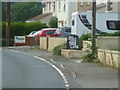
Save lifes!
A sandwich board on the B3151 propounds the familiar line, albeit with a slight error.
Image: © Neil Owen
Taken: 26 Jun 2020
0.03 miles
4
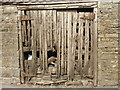
A rickety wooden door
A wooden barn door, left to its own devices.
Image: © Neil Owen
Taken: 26 Jun 2020
0.04 miles
5
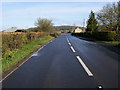
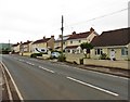
The B3151 Main Road
The B3151 Main Road heading out of Compton Dundon towards Street
Image: © Shaun Ferguson
Taken: 6 Apr 2008
0.11 miles
6
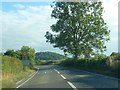
B3151 Entering Compton Dundon
Town boundary as you come down Main Road, B3151, from the North.
Image: © Steve Barnes
Taken: 12 Aug 2010
0.22 miles