IMAGES TAKEN NEAR TO
Newtown Park, LANGPORT, TA10 9TF
Introduction
This page details the photographs taken nearby to Newtown Park, TA10 9TF by members of the Geograph project.
The Geograph project started in 2005 with the aim of publishing, organising and preserving representative images for every square kilometre of Great Britain, Ireland and the Isle of Man.

There are currently over 7.5m images from over14,400 individuals and you can help contribute to the project by visiting https://www.geograph.org.uk
Image Map (Loading...)


Getting Data...Please wait
Leaflet Map data © OpenStreetMap
Images are licensed for reuse under creativecommons.org/licenses/by-sa/2.0
Notes
- Clicking on the map will re-center to the selected point.
- The higher the marker number, the further away the image location is from the centre of the postcode.
Image Listing (9 Images Found)
Images are licensed for reuse under creativecommons.org/licenses/by-sa/2.0
Image
Details
Distance
1
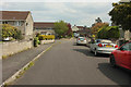
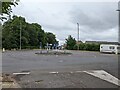
Newtown Park, Langport
A cul-de-sac on the northern fringe of the town.
Image: © Derek Harper
Taken: 13 Apr 2019
0.03 miles
2
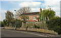
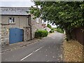
House, Langport
Newtown Cottage is at the junction of Image] with the A372 Newtown Road (left).
Image: © Derek Harper
Taken: 13 Apr 2019
0.07 miles
3
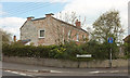
House, Langport
Newtown Cottage is also shown in Image]; this view is across the A372 Newtown Road.
Image: © Derek Harper
Taken: 13 Apr 2019
0.07 miles
4

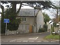
A372 Newtown Road, Langport
From the same junction as Image
Image: © Derek Harper
Taken: 13 Apr 2019
0.09 miles
5
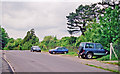
Wearne Lane, Wearne, Somerset
Junction of Wearne Lane and the A372. House in picture is the Old Coach House.
Image: © Ruth Sharville
Taken: 9 Feb 2007
0.18 miles
6
Junction at the southern end of Wearne Lane
Image: © Rob Purvis
Taken: 23 Jul 2022
0.18 miles
8
Site of former Langport East station
View westward, towards Taunton and the West: ex-GWR London - Reading - Westbury - Taunton - Exeter - Plymouth - Penzance main line. A boring scene, but the railway is on the right and there was a station here until 10/9/62.
Image: © Ben Brooksbank
Taken: 16 May 2001
0.25 miles
9
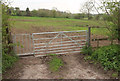
Field by Combe Lane
To the left of the scene in Image Public footpath L 13/53 uses the gate on the left, although it's not mapped as entering the field here.
Image: © Derek Harper
Taken: 13 Apr 2019
0.25 miles