IMAGES TAKEN NEAR TO
The Avenue, LANGPORT, TA10 9SA
Introduction
This page details the photographs taken nearby to The Avenue, TA10 9SA by members of the Geograph project.
The Geograph project started in 2005 with the aim of publishing, organising and preserving representative images for every square kilometre of Great Britain, Ireland and the Isle of Man.

There are currently over 7.5m images from over14,400 individuals and you can help contribute to the project by visiting https://www.geograph.org.uk
Image Map (Loading...)


Getting Data...Please wait
Leaflet Map data © OpenStreetMap
Images are licensed for reuse under creativecommons.org/licenses/by-sa/2.0
Notes
- Clicking on the map will re-center to the selected point.
- The higher the marker number, the further away the image location is from the centre of the postcode.
Image Listing (31 Images Found)
Images are licensed for reuse under creativecommons.org/licenses/by-sa/2.0
Image
Details
Distance
1
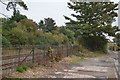
A378 crossed by the railway
The railway line joins Frome and Taunton.
Image: © Stuart Logan
Taken: 9 Oct 2013
0.05 miles
3

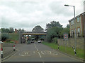
Langport Telephone Exchange
Situated in Old Market Square off the A378 North Street, this modern TE would have replaced a smaller building from the GPO era during the early 1970s. Besides Langport, this TE also serves Aller, Bramwell, Curry Rivel, Drayton, Henley, High Ham, Huish Episcopi, Low Ham, Muchelney, Pibsbury, Pitney and Wearne nearby. This TE has (01458) 25xxxx numbers, the (01458) referring to the Glastonbury group of TEs, and its postcode is TA10 9RP.
Image: © David Hillas
Taken: 30 Sep 2011
0.08 miles


8
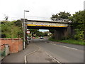
Site of former railway station at Langport East
The site of the station building can be seen in this shot: Image
Image: © Roger Cornfoot
Taken: 21 Sep 2016
0.12 miles
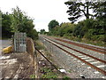
9

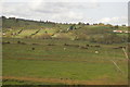
Site of former Langport East station
View westward, towards Taunton and the West: ex-GWR London - Reading - Westbury - Taunton - Exeter - Plymouth - Penzance main line. A boring scene, but the railway is on the right and there was a station here until 10/9/62.
Image: © Ben Brooksbank
Taken: 16 May 2001
0.13 miles