IMAGES TAKEN NEAR TO
Aller, LANGPORT, TA10 0QR
Introduction
This page details the photographs taken nearby to TA10 0QR by members of the Geograph project.
The Geograph project started in 2005 with the aim of publishing, organising and preserving representative images for every square kilometre of Great Britain, Ireland and the Isle of Man.

There are currently over 7.5m images from over14,400 individuals and you can help contribute to the project by visiting https://www.geograph.org.uk
Image Map
Images are licensed for reuse under creativecommons.org/licenses/by-sa/2.0
Notes
- Clicking on the map will re-center to the selected point.
- The higher the marker number, the further away the image location is from the centre of the postcode.
Image Listing (29 Images Found)
Images are licensed for reuse under creativecommons.org/licenses/by-sa/2.0
Image
Details
Distance
2
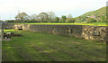
Churchyard extension, Aller
Taken from the same spot as Image], looking in the opposite direction. Aller and Aller Hill are on the right.
Image: © Derek Harper
Taken: 6 May 2019
0.02 miles
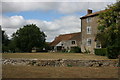
4
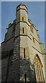
Stair-turret, Church of St Andrew, Aller
"North west octagonal stair turret capped with spirelet" https://historicengland.org.uk/listing/the-list/list-entry/1227327 . It rises higher than the tower.
Image: © Derek Harper
Taken: 6 May 2019
0.02 miles
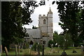
7
Church of St Andrew, Aller
The grade II* listed church is described at https://historicengland.org.uk/listing/the-list/list-entry/1227327 .
Image: © Derek Harper
Taken: 6 May 2019
0.02 miles
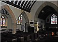
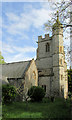
8
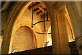
Church of St Andrew, Aller
"The under-tower space unusual - it seems to be originally designed as a crossing tower, with arches to north, east and south, and flying arched braces to nave walls" https://historicengland.org.uk/listing/the-list/list-entry/1227327 . Pevsner (South and West Somerset, 1958) is also puzzled. "The w tower on the ground floor opens towards the nave with responds of the standard four-hollows design, but the members are treated so broadly and the capitals are so large and simple that the date is certain. In addition the same arches are repeated N and S so as to lead into former embracing aisles or indeed projected transepts". The church is grade II* listed.
Image: © Derek Harper
Taken: 6 May 2019
0.02 miles
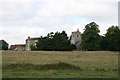
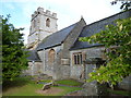
9
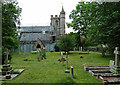
St Andrew, Aller
Church and farm stand a little way from the village. On this site, Alfred the Great reputedly witnessed the baptism of Guthrum in 878 after the Battle of Edington (Image]). Nothing extant is earlier than the C11th or C12th. Grade II* listed.
The roof was being repaired at the time.
Image: © Stephen Richards
Taken: 11 Aug 2017
0.03 miles