IMAGES TAKEN NEAR TO
Church Path, LANGPORT, TA10 0QP
Introduction
This page details the photographs taken nearby to Church Path, TA10 0QP by members of the Geograph project.
The Geograph project started in 2005 with the aim of publishing, organising and preserving representative images for every square kilometre of Great Britain, Ireland and the Isle of Man.

There are currently over 7.5m images from over14,400 individuals and you can help contribute to the project by visiting https://www.geograph.org.uk
Image Map
Images are licensed for reuse under creativecommons.org/licenses/by-sa/2.0
Notes
- Clicking on the map will re-center to the selected point.
- The higher the marker number, the further away the image location is from the centre of the postcode.
Image Listing (25 Images Found)
Images are licensed for reuse under creativecommons.org/licenses/by-sa/2.0
Image
Details
Distance
8
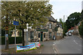
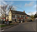
Old Direction Sign - Signpost by the A372, High Street, Aller
Pyramid finial - 2 arms; Somerset SCC pyramid by the A372, in parish of Aller (South Somerset District), Church Path junction with High Street, by Old Pound Inn.
Surveyed
Milestone Society National ID: SO_ST4029
Image: © Alan Rosevear
Taken: 21 Nov 2012
0.14 miles