IMAGES TAKEN NEAR TO
White Hill, LANGPORT, TA10 0QH
Introduction
This page details the photographs taken nearby to White Hill, TA10 0QH by members of the Geograph project.
The Geograph project started in 2005 with the aim of publishing, organising and preserving representative images for every square kilometre of Great Britain, Ireland and the Isle of Man.

There are currently over 7.5m images from over14,400 individuals and you can help contribute to the project by visiting https://www.geograph.org.uk
Image Map (Loading...)


Getting Data...Please wait
Leaflet Map data © OpenStreetMap
Images are licensed for reuse under creativecommons.org/licenses/by-sa/2.0
Notes
- Clicking on the map will re-center to the selected point.
- The higher the marker number, the further away the image location is from the centre of the postcode.
Image Listing (13 Images Found)
Images are licensed for reuse under creativecommons.org/licenses/by-sa/2.0
Image
Details
Distance
1
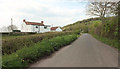
Lane approaching A372
Further west along the lane shown in Image The A372, arriving from the left, swings left (west from Langport) at the crossroads; the lane climbing on the right continues the line of the main road, and also uses the name "White Hill".
Image: © Derek Harper
Taken: 13 Apr 2019
0.02 miles
2
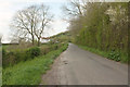
Lane from Wearne
Approaching the junction with the A372 at White Hill.
Image: © Derek Harper
Taken: 13 Apr 2019
0.03 miles
3
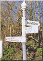
Old Direction Sign - Signpost by the A372, White Hill, west of Wearne
Pyramid finial - 3 arms; Somerset SCC pyramid by the A372, in parish of Huish Episcopi (South Somerset District), White Hill junction with two lanes, West of Wearne, North of Langport.
Surveyed
Milestone Society National ID: SO_ST4228.
Image: © Milestone Society
Taken: Unknown
0.03 miles
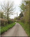
6
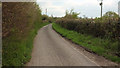
Combe Lane
Looking in the other direction from where Image] was taken.
Image: © Derek Harper
Taken: 13 Apr 2019
0.13 miles
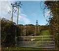
8
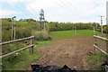
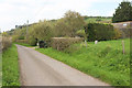
Hillside field, Combe
From a gateway on Combe Lane; the trees at the top end of the field border the A372.
Image: © Derek Harper
Taken: 13 Apr 2019
0.16 miles
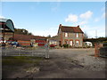
10
Combe Lane
From where Image] was taken, and approaching most of the hamlet of Combe.
Image: © Derek Harper
Taken: 13 Apr 2019
0.17 miles