IMAGES TAKEN NEAR TO
Curry Rivel, LANGPORT, TA10 0NU
Introduction
This page details the photographs taken nearby to TA10 0NU by members of the Geograph project.
The Geograph project started in 2005 with the aim of publishing, organising and preserving representative images for every square kilometre of Great Britain, Ireland and the Isle of Man.

There are currently over 7.5m images from over14,400 individuals and you can help contribute to the project by visiting https://www.geograph.org.uk
Image Map (Loading...)


Getting Data...Please wait
Leaflet Map data © OpenStreetMap
Images are licensed for reuse under creativecommons.org/licenses/by-sa/2.0
Notes
- Clicking on the map will re-center to the selected point.
- The higher the marker number, the further away the image location is from the centre of the postcode.
Image Listing (4 Images Found)
Images are licensed for reuse under creativecommons.org/licenses/by-sa/2.0
Image
Details
Distance
1
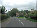
A378 is Churchway in Curry Rivel
The unusual name Curry Rivel, comes from the Celtic word crwy, meaning boundary and Rivel from its 12th-century landlord Sir Richard Revel. In 1237 the King granted Henry de l'Orti a licence to empark his woods in Curry Rivel separating them from the control of the foresters of Castle Neroche. Curry Rivel was part of the hundred of Abdick and Bulstone. See: http://en.wikipedia.org/wiki/Curry_Rivel
Image: © Stuart Logan
Taken: 9 Oct 2013
0.02 miles
4
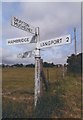
Direction Sign - Signpost on the crossroads of Drayton Lane and Back Lane
Pyramid finial - 4 arms; Somerset SCC pyramid by the UC road, in parish of Curry Rivel (South Somerset District), on the west side of the crossroads of Drayton Lane and Back Lane.
surveyed
Milestone Society National ID: SO_ST3925A
Image: © Milestone Society
Taken: Unknown
0.25 miles