IMAGES TAKEN NEAR TO
Drayton, LANGPORT, TA10 0JU
Introduction
This page details the photographs taken nearby to TA10 0JU by members of the Geograph project.
The Geograph project started in 2005 with the aim of publishing, organising and preserving representative images for every square kilometre of Great Britain, Ireland and the Isle of Man.

There are currently over 7.5m images from over14,400 individuals and you can help contribute to the project by visiting https://www.geograph.org.uk
Image Map (Loading...)


Getting Data...Please wait
Leaflet Map data © OpenStreetMap
Images are licensed for reuse under creativecommons.org/licenses/by-sa/2.0
Notes
- Clicking on the map will re-center to the selected point.
- The higher the marker number, the further away the image location is from the centre of the postcode.
Image Listing (29 Images Found)
Images are licensed for reuse under creativecommons.org/licenses/by-sa/2.0
Image
Details
Distance
2
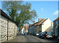
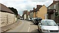
Church Street, Drayton
Approaching the centre of Drayton from the west.
Image: © Robin Drayton
Taken: 8 May 2009
0.04 miles
3
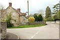
Junction in Drayton
School Street (left) meets Church Street, with Court Cottage on the corner - it dates originally from the C16 and is described along with its other half at https://www.historicengland.org.uk/listing/the-list/list-entry/1236573 . On the right, behind the wall and hedge, are the grounds of Drayton Court, the former rectory.
Image: © Derek Harper
Taken: 16 Apr 2016
0.05 miles
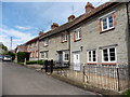
4
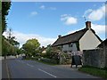
School Street, Drayton
Cottages along the village street, arriving from Whitecross.
Image: © Derek Harper
Taken: 16 Apr 2016
0.06 miles
5
Drayton Village Hall
The plaque above the entrance door says 'Parish School 1850'.
Image: © Robin Drayton
Taken: 8 May 2009
0.07 miles
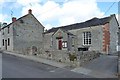
6
The Old Post Office, Church Street, Drayton
Image: © Robin Drayton
Taken: 8 May 2009
0.07 miles
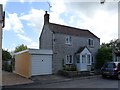
8
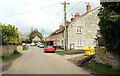
Church Street, Drayton
On the left is the outbuilding glimpsed, again on the left, in Image
Image: © Derek Harper
Taken: 16 Apr 2016
0.08 miles
9
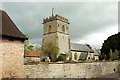
Church of St Catherine, Drayton
The grade I listed church, seen from Church Street, is described at https://www.historicengland.org.uk/listing/the-list/list-entry/1236512 . On the right, topped by a ball finial, is the grade II* lasted churchyard cross, described at https://www.historicengland.org.uk/listing/the-list/list-entry/1236539 and at https://www.historicengland.org.uk/listing/the-list/list-entry/1018637 .
Image: © Derek Harper
Taken: 16 Apr 2016
0.09 miles
10
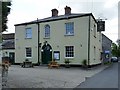
The Drayton Arms public house, Church Street
Image: © Robin Drayton
Taken: 8 May 2009
0.10 miles