IMAGES TAKEN NEAR TO
Burton Close, LANGPORT, TA10 0AF
Introduction
This page details the photographs taken nearby to Burton Close, TA10 0AF by members of the Geograph project.
The Geograph project started in 2005 with the aim of publishing, organising and preserving representative images for every square kilometre of Great Britain, Ireland and the Isle of Man.

There are currently over 7.5m images from over14,400 individuals and you can help contribute to the project by visiting https://www.geograph.org.uk
Image Map
Images are licensed for reuse under creativecommons.org/licenses/by-sa/2.0
Notes
- Clicking on the map will re-center to the selected point.
- The higher the marker number, the further away the image location is from the centre of the postcode.
Image Listing (7 Images Found)
Images are licensed for reuse under creativecommons.org/licenses/by-sa/2.0
Image
Details
Distance

3

A378 approaches crossroads with Heale Lane
Image: © Stuart Logan
Taken: 9 Oct 2013
0.11 miles
4
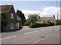
Holden's Way, Curry Rivel
Holden's Way is the lane slanting diagonally off the A378, between Garland House and Thatcher's Cottage, and leading towards the Isle valley.
Image: © Derek Harper
Taken: 19 May 2007
0.11 miles
5
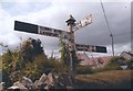
Old Direction Sign - Signpost by the A378, west of Curry Rivel
Pyramid finial - 3 arms; Somerset SCC pyramid by the A378, in parish of Curry Rivel (South Somerset District), opposite junction with Heale Lane.
Surveyed
Milestone Society National ID: SO_ST3824.
Image: © Milestone Society
Taken: Unknown
0.12 miles

7

Field by the footpath to Burton Pynsent monument
Image: © David Smith
Taken: 21 Apr 2017
0.24 miles