IMAGES TAKEN NEAR TO
Lower Wiltown, LANGPORT, TA10 0AD
Introduction
This page details the photographs taken nearby to Lower Wiltown, TA10 0AD by members of the Geograph project.
The Geograph project started in 2005 with the aim of publishing, organising and preserving representative images for every square kilometre of Great Britain, Ireland and the Isle of Man.

There are currently over 7.5m images from over14,400 individuals and you can help contribute to the project by visiting https://www.geograph.org.uk
Image Map (Loading...)


Getting Data...Please wait
Leaflet Map data © OpenStreetMap
Images are licensed for reuse under creativecommons.org/licenses/by-sa/2.0
Notes
- Clicking on the map will re-center to the selected point.
- The higher the marker number, the further away the image location is from the centre of the postcode.
Image Listing (4 Images Found)
Images are licensed for reuse under creativecommons.org/licenses/by-sa/2.0
Image
Details
Distance
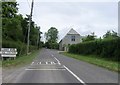
1
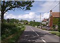
Road past Marsh Farm
The B3168 passing the cluster of buildings at Marsh Farm on its way from Hambridge to Curry Rivel.
Image: © Derek Harper
Taken: 19 May 2007
0.13 miles
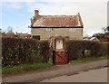
3
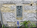
Ordnance Survey Flush Bracket 1711
This can be found on the wall of a cottage in Back Lane.
For more detail see : http://www.bench-marks.org.uk/bm2889
Image: © Peter Wood
Taken: 3 Apr 2014
0.18 miles