IMAGES TAKEN NEAR TO
Little Hereford, LUDLOW, SY8 4LW
Introduction
This page details the photographs taken nearby to SY8 4LW by members of the Geograph project.
The Geograph project started in 2005 with the aim of publishing, organising and preserving representative images for every square kilometre of Great Britain, Ireland and the Isle of Man.

There are currently over 7.5m images from over14,400 individuals and you can help contribute to the project by visiting https://www.geograph.org.uk
Image Map (Loading...)


Getting Data...Please wait
Leaflet Map data © OpenStreetMap
Images are licensed for reuse under creativecommons.org/licenses/by-sa/2.0
Notes
- Clicking on the map will re-center to the selected point.
- The higher the marker number, the further away the image location is from the centre of the postcode.
Image Listing (4 Images Found)
Images are licensed for reuse under creativecommons.org/licenses/by-sa/2.0
Image
Details
Distance
1
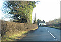
White Cottage along A456
Approaching Broad Field from the west, Kink in River Teme lies just east of house
Image: © John Firth
Taken: 22 Dec 2011
0.03 miles
3
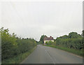
House on A456 just past the Cliffs drive
Looking west
Image: © John Firth
Taken: 27 Dec 2011
0.05 miles
4
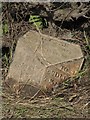
Old Milepost by the A456, Little Hereford parish
Cast iron post by the A456, in parish of LITTLE HEREFORD (District), West of Chestnut Cottage, on verge. Hereford iron T-post, erected by the Tenbury turnpike trust in the 19th century.
Inscription reads:-
: TO / TENBURY / 2 / MILES : : LITTLE / HEREFORD / PARISH : : TO / LUDLOW / 7 / MILES / LEMSTER / 9 :
Herefordshire SMR.
SMR Number: 56557 https://www.heritagegateway.org.uk/Gateway/Results_Single.aspx?uid=MHE28314&resourceID=101
Milestone Society National ID: HF_TBLD02.
Image: © TE Keegan
Taken: 17 Feb 2013
0.07 miles