IMAGES TAKEN NEAR TO
Bleathwood, LUDLOW, SY8 4LP
Introduction
This page details the photographs taken nearby to SY8 4LP by members of the Geograph project.
The Geograph project started in 2005 with the aim of publishing, organising and preserving representative images for every square kilometre of Great Britain, Ireland and the Isle of Man.

There are currently over 7.5m images from over14,400 individuals and you can help contribute to the project by visiting https://www.geograph.org.uk
Image Map
Images are licensed for reuse under creativecommons.org/licenses/by-sa/2.0
Notes
- Clicking on the map will re-center to the selected point.
- The higher the marker number, the further away the image location is from the centre of the postcode.
Image Listing (14 Images Found)
Images are licensed for reuse under creativecommons.org/licenses/by-sa/2.0
Image
Details
Distance
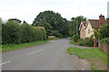
2
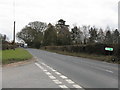
Junction for Bleathwood at Ledwich Bridge
From eastbound A456
Image: © John Firth
Taken: 22 Dec 2011
0.06 miles
3
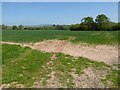
Arable field
Arable field near Little Hereford, Titterstone Clee Hill can be seen in the distance.
Image: © Philip Halling
Taken: 10 May 2017
0.08 miles
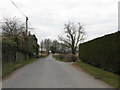
4
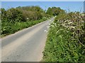
Country road near Little Hereford
This unclassified country road off the A456 near Little Hereford eventually goes to Ludlow. Despite a very dry spring, the verges are growing with cow parsley in flower.
Image: © Philip Halling
Taken: 10 May 2017
0.08 miles
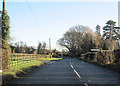
5
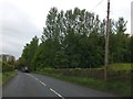
A456 near Broadfields
The trees on the right screen greenhouses
Image: © David Smith
Taken: 20 May 2013
0.09 miles
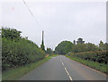
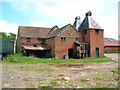
9
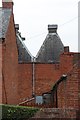
Oast House at Burford Mill, Burford
Image: © Oast House Archive
Taken: 12 Sep 2014
0.17 miles